Bangkok shares many similarities with its fellow Asian mega-cities; including snarling traffic, explosive growth, tasty street food and a multiplicity of cultures. However, Bangkok’s canal-inspired street layout complicates and lengthens daily commutes for its residents in a way that sets it apart from neighboring cities. Yet despite the obvious negatives, its nonsensical street pattern could become Bangkok’s saving grace.
Many articles blame Bangkok’s horrendous traffic and long commutes on the usual culprits, poor planning and rapid growth, but there’s something more unique going on in Bangkok. Dr. Apiwat Ratanawaraha, of the city’s Urban Design and Development Center and a faculty member at Chulalongkorn University’s Department of Urban and Regional Planning, credits the traditional process of inheriting land for the city’s current network of streets. Agricultural land was owned and passed down from generation to generation within families. It was important to give each successive generation access to one of the region’s many canals, because farmers could not easily bring their produce to market without the waterways. This process resulted in increasingly narrow properties as families grew and divided their land among children. As Bangkok grew and farmers converted their agricultural land into housing and businesses, most farmers built small streets or “sois” down the middle of their already narrow properties. This practice maximized profit by allowing development of land on both sides of the new soi, but it also led to modern Bangkok’s inefficient system of roads.
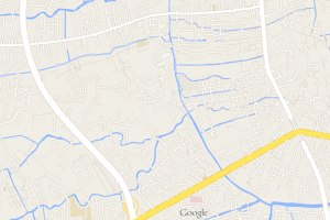
Fast forward to the present-day, and a map of Bangkok reveals a loose web of large highways with a seemingly typical jumble of smaller roads connecting the areas in between. Closer investigation reveals a city made up of large super-blocks with tendril-like lanes that branch into even smaller streets before dead-ending into canals. These canals once served as important transportation corridors, but their significance has faded as the city’s reliance on roads has increased. Many of the waterways have even been paved over. The lanes that fill the super-blocks are often the long, narrow sois that run parallel to one another and connect the main highway to a small number of tributary dead-ends. These sois are no longer the inconsequential creations of entrepreneurial farmers converting land to development. Instead, they are an undeniable cause of constant gridlock, hours-long commutes, and high air pollution.
For an American, this system is reminiscent of sprawling subdivisions purposefully designed to have one entry and exit. The congestion associated with this type of design is well documented in low-density areas of the United States but it becomes even more severe when replicated in dense Bangkok. This unique transportation fabric has many implications for the city — both good and bad — and a better understanding of this idiosyncrasy can allow city leaders to capitalize on its strengths while diminishing its negatives.
Many cities start out with a similarly disorganized and under-developed street network. Usually, as the city grows, the municipal government will add secondary roads and highways to the city. According to Dr. Ratanawaraha, such roads were never adequately built in Bangkok, because the city government has been concerned that using its authority to appropriate land for road development will upset the public. This non-confrontational style of governance means that, as of 2013, the city has carried out only one “land readjustment project” to connect two streets.
Experts recommend that 20 to 25 percent of a city’s land area be devoted to streets for optimal multi-modal transportation. Bangkok’s pattern of development has led to just 10 percent of the city’s area being committed to roadways. This is a very low road density when compared to other world cities – even dense ones such as Tokyo and New York City, which have road densities of 23 and 38 percent respectively. Bangkok’s narrow, disconnected sois will remain that way unless the government changes course and decides to stomach the high financial cost of road-widening and the social cost of upsetting influential landowners who have already invested heavily in their properties. It’s unlikely that a city unwilling to undertake these small challenges will successfully acquire the amount of land it needs to increase its road density to the 20 percent threshold. However, without such a move, Bangkok will never be able to accommodate its residents’ demands for more automobile traffic.
The inability to accommodate cars, however, is only a net negative if one looks at automobiles as the only source of mobility and accessibility. Bangkok could choose to make use of its uniquely Thai street network and non-confrontational governing history to chart a different, non-car-oriented path. If Bangkok decides to diversify its transportation plans, its low density of roads and unwillingness to appropriate land for new road construction could become assets for sustainable development rather than a hindrance to growth.
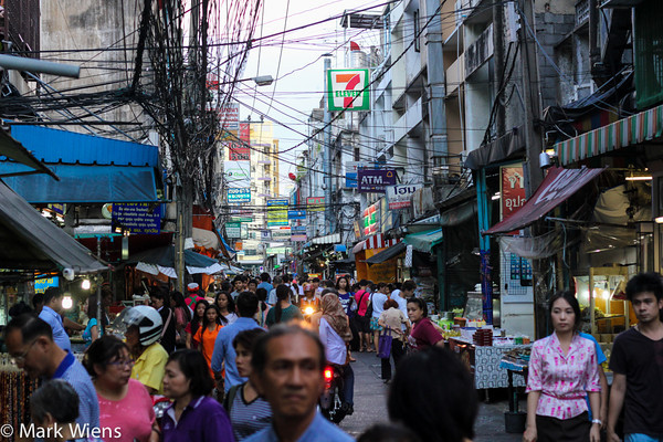
There would be many positive outcomes of aggressively retrofitting sois for the types of transport they were designed for: bicycles and pedestrians. The preservation of the soi network would mean that, unlike many Asian cities where governments have swept away historic neighborhoods, much of Bangkok would continue to be a collection of small human-scale neighborhoods reminiscent of the medieval European cities idealized in the West. It’s not too late to save these organic mixed-use neighborhoods. The sidewalks are messy and crowded with pedestrians, shopkeepers and even motorcyclists jostling for the limited space, but it’s easy to imagine policies designed to favor pedestrians and sidewalks over drivers could make walking down a soi a positive experience. New policies could even make Bangkok a model for other Asian mega-cities hoping to preserve their cultural heritage in the face of explosive growth and development.

Vendors and pedestrians dominate on Silom Road Soi 20. Photo courtesy of Mark Wiens at Migrationology.com
Of course, a city the size of Bangkok cannot rely solely on pedestrians and bicycle activity. The suggested soi retrofitting will have to take place in tandem with the expansion of the city’s elevated and underground rail systems. This is already in the works, with three new Sky Train stations added in the past year and a subway line extension scheduled to open within a year. A master plan with nineteen new rail lines (scheduled to be completed by 2029) is slowly coming to fruition. Completing these lines will make car-free commuting realistic around much of the city. This shift would make it easier to convince policy makers and residents alike to invest in the improved walkability of Bangkok’s existing human-scaled streets instead of the dramatic and costly construction of new auto-oriented infrastructure in the city’s neighborhoods.
Some urban planners, designers and architects in the city are already working to jump-start this transition. The Urban Design and Development Center (UDDC), a Bangkok-based urban planning “Think-and-Do-Tank,” is currently developing a walkability index for the city. The index, based on Walk Score and similar systems, will show which areas of the city have the hallmarks of walkable neighborhoods — mixed-use development, wide sidewalks, street trees, crosswalks — and which areas do not. UDDC then hopes to acquire funding to retrofit intersections in districts with high potential to showcase what a walkable Bangkok could look like. Adding crosswalks, improving sidewalks, incentivizing shade-giving awnings and trees, and providing formal pick-up and drop-off zones for motorcycle taxis are among the strategies UDDC hopes to deploy in the city. The program also has a special emphasis on walkability for health, which reflects the fact that much of its funding comes from the Thai Health Department.
It is often said that necessity is the mother of invention. Bangkok’s low street-density and historically non-confrontational municipal government have created an urban environment that simply cannot cope with the current or projected levels of car ownership. Implementing strategies to improve walkability in tandem with the expansion of rail could temper rising automobile use and transform this historic liability into an asset. Success would not only set Bangkok on a more sustainable trajectory, but it would also preserve the city’s human-scaled sois and the cultural capital that thrives along them.


