By the same token, our cathedrals of the game don’t always fit the urban mold seamlessly. Like U.S. Cellular Field in South Side Chicago, some sting of gentrification. Others, like the Atlanta Braves’ new Cobb County stadium, pander to white and wealthy suburban residents, proving the “quest for money trumps the idea that our teams can be — and should be — a part of their community, an aspect of a city’s society that brings all types of people together in one place” (Waldron).

Rendering of the Atlanta Braves’ new Cobb County Stadium
The Detroit Advantage
Detroit has the potential to utilize the power of its downtown venues to take the lead in the rising field of sustainable sports. Admittedly, talk of “potential” probably did not ease the minds of the Big Four franchise owners in the Motor City home as they watched the city’s population drop by 25% in the first decade of the 21st century alone, but the Tigers just had their top two best-selling seasons in the franchise’s 117 year history. When teams perform, Michiganders will show up, regardless of the stadium’s location.
Even in Detroit, downtown urban land has value. It provides versatility, accessibility, socio-economic crossover and interaction, and the gritty physical connection between the team and the Motor City. It is also relatively cheap and there is a whole lot of it, which gives Detroit a competitive advantage and the chance to take the lead in establishing long-term sustainable development projects, such as transit integration and renewable energy practices where other cities often have greater concerns over existing land usage.
Since property values took a turn from bad to worse, there’s been a push for more sustainable use of Detroit’s public lands, particularly in the inner city; “repurposing vacant land in ways that add economic, environmental, and social benefits to Detroiters is part of the vision laid out in the Detroit Future City strategic framework introduced in January.” The goal is the creation of a healthier and more sustainable urban ecosystem in a region known for pollution, rust, and grit. With so much vacant property, the most crucial resource for urban development projects – cheap space – is readily available.
A Sustainable Example
The San Francisco 49ers have set the bar high by building a new stadium that uses solar power to generate enough energy for all ten preseason and regular season home football games. That means the sun is powering lights, video boards, speakers, locker rooms, suites, and concourses for an entire season thanks to 38,000 square feet of photovoltaics and a progressive California subsidy or two. To make the deal even sweeter, over sixteen types of native plants grow on Levi’s Stadium’s green roof, all water for irrigation and plumbing is reclaimed, and there are light rail stops and bike racks just outside the stadium. According to Sports Illustrated, some fans have made plans to walk as far as four miles to a 49ers game this year due to the focus on safety, accessibility, and alternative transit.
The Levi’s Stadium website touts a number of other sustainable achievements, such as its LEED Gold certification, the first of any professional American football stadium, use of recycled wood for the owner’s suites, and composting. The new sleek Levi’s Stadium facility is a far cry from the 49ers old home at Candlestick Park, which received quite a bit of scorn over the years for its poor seating design and more recently for back-to-back in-game power outages during Monday Night Football in 2013. While the 49ers’ new facility may be best-in-class, it is not the only NFL stadium making pacts to integrate intelligently with its urban environment. The Giants’ and Jets’ Metlife Stadium signed a memorandum with the EPA in 2009 pledging to be an environmental steward by employing a number of carbon reduction methods. These include composting, a certified “Green Restaurant,” energy savings through efficient metering and monitoring, and even a rooftop solar ring.
The Braves’ Cobb County Stadium
On the other side of the country, the Atlanta Braves are dropping millions to pander to the wealthiest fans with hardly a mention of renewable energy projects, despite prime solar energy location in a city where the sun is shining 60% of the year. The Cobb County relocation proves that franchises believe they can thrive by avoiding the struggles that come with being a part of a complex community that includes poor and minority citizens. As much as one positions the move as an economic decision, the city government and franchise are shirking their collective responsibility to take care of and invest in their constituents by building safe transportation infrastructure and integrating effectively with the urban landscape. Fleeing from the troubled areas of the inner city is a kick in the gut to the most loyal fans — the urban laborer who spends an entire year’s overtime to take his son to a game, or the thousands who rely on the stadium for income. Will the new venue just leave behind more unemployment, vacant land, crime, and resentment? Will Georgia State be able to put together a redevelopment deal for “The Ted”?
Additionally, Braves executive David Schiller has repeatedly emphasized that the new stadium will promote automobile infrastructure to increase car accessibility, which “starts with roadways.” This ignores the importance of sports as part of the urban transit nexus and caters to exclusionary suburban values.
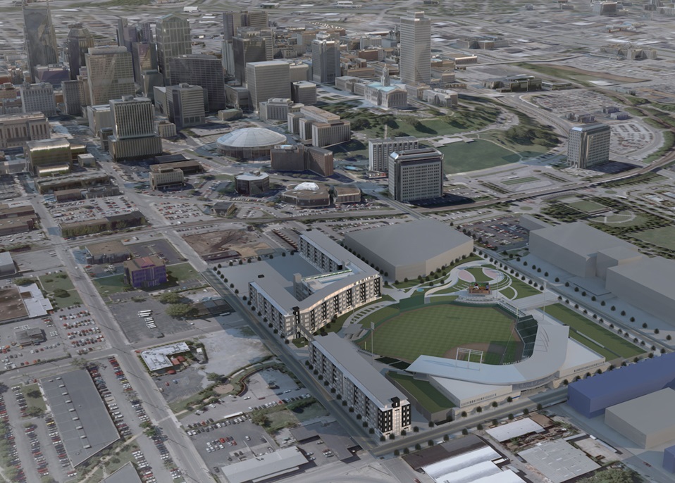
The New Detroit Entertainment District
Back in July 2014, the Ilitch family — owners of the Tigers and Red Wings franchises — provided the first renderings of Detroit’s new Red Wings Arena and surrounding sports and entertainment district, which seeks to integrate a new 20,000+ seat hockey venue with Comerica Park, Ford Field, and brand new retail, business, and residential space spanning over 45 blocks. Christopher Illitch estimates that the new district will “create at least $1.8 billion in total economic impact over several years, 8,300 construction and construction-related jobs, and 1,100 permanent jobs,” while rivaling the bustling street life found in many European cities. Among the plans are a commitment to creating five new neighborhoods in the area that are modeled after European streets, walkable, and transit-oriented, as well as sustainable and innovative arena design and grade separation over the I-75 corridor.
The availability of plentiful land downtown has allowed franchise owners like the Illitches and other private investors to carve out a powerful economic district in the heart of Detroit, and they have chosen to anchor it with sports venues, most notably the $450 million Red Wings Arena. The sports-centric entertainment hub, which broke ground last September, is estimated to be ready by Summer 2017 and is a promising example of Detroit’s commitment to revitalizing urban property.
It is imperative that sporting programs, franchises, and facilities recognize their influence as representatives of community identity and stewards of their cities’ values. Aside from the raw benefits for the environment, downtown stadiums employing sustainable design practices will associate “greenness” with urban community investment, rather than simply as a luxury for the wealthy and suburban. The payoff will be immense for franchises that can acknowledge the challenges of their city’s core, recognize their role as a part of that community, and learn to utilize urban property to its full potential. Rather than fleeing to the suburbs, the most visionary owners will create a sustainable operating model and integrate more effectively with their human and natural environments.
In Detroit, you find a third of the city’s residential lots vacant; beautiful architecture sitting unused; the old Tiger Stadium demolished, awaiting final plans for redevelopment; and Comerica Park adjacent to Ford Field, creating potential for collaboration and vast roof space for photovoltaics or vegetation. Most importantly, you find a thriving downtown sports culture and an exciting new integrated entertainment district plan, spearheaded by franchise owners and the Downtown Development Association, that will give new life to the neglected area between Detroit’s downtown core and the midtown University district. Urban property remains powerful, sustainable urban integration has never been more important, and the city needs a public image overhaul.
Now is the perfect opportunity for Detroit to take the lead.
The Bastakiya Quarter, located along the south bank of Dubai Creek, was once a thriving middle class neighborhood. A century ago, Dubai was one of the world’s centers of pearl diving. With the rise of machine-made pearls in the 1930s, pearl diving and the Bastakiya Quarter began to decline. The UAE oil boom did not commence until the 1960s, but the area experienced a rebirth a decade earlier when the Dubai Creek was dredged and widened to accommodate larger cargo ships from all over the Middle East and Africa. Today, the Bastakiya Quarter is a popular tourist attraction and home to numerous shops, restaurants, art galleries, and cultural institutions like the Sheikh Mohamed Center for Cultural Understanding (URL: www.cultures.ae). SMCCU offers walking tours of Bastakiya multiple times a week.
The Bastakiya Quarter got its name from the Iranian city of Bastak, a city on the southern coast from which many present-day Emirati families immigrated by boat. Emiratis, like many peoples in the Arabian Gulf region, were originally nomadic and were used to packing up their home and relocating. Today, Emiratis, even the lower classes, are not nomadic due to progressive government policies in the 1990s, but many natives have nomadic Bedouin bloodlines.
In Bastakiya, one can see two different types of housing stock originally common in Bastak, Iran. While they were the predominant housing styles for two different socioeconomic classes, they each used innovative techniques for dealing with Dubai’s brutal heat and both take advantage of reprieve in the form of cooling desert winds.

an “al kaimah” house
On the right in the photo above is an example of an “al kaimah” house. The home’s style is primitive, reflecting the Emiratis’ Bedouin and nomadic roots. It was the home style of choice for lower-middle class citizens. These houses are made of palm tree fibers, making them structurally durable but susceptible to fire. However, the palm tree fibers also allow air to pass through, keeping the house cool in summer.
Middle class families opted to live in the style of house shown on the left side of the previous photo. This style, known as “al arish,” is a more proper multi-family dwelling. Al arish houses consist of multiple rooms surrounding a central courtyard, offering more privacy than al kaimah houses, which are basically oversized multi-family huts. The central courtyard often has a large tree to provide shade, but the home has another key feature that offers a superior level of cooling technology.

A wind tower with an Al arish house.
Al arish houses are famous for their wind towers. Wind towers send cold air downward into a portion of a room directly underneath the tower, away from the doorway to the central courtyard. In summer, families would cram themselves into the room with a wind tower above; alternatively, families would offer this room to overnight guests. In essence, wind towers were one of the most primitive forms of air conditioning with a family’s wealth illustrated by the number of wind towers in their home. Today, buildings that are meant to look “traditional,” such as the Madinat Jumeirah resort, incorporate wind towers in the design, but only for decoration (thanks to modern day air conditioners).
It is worth noting that the Bastakiya neighborhood was planned to control the weather as well. There are numerous courtyards with large shade trees, and houses were built very close together so the streets/alleys would double as powerful wind tunnels.
The planning behind Bastakiya neighborhood encompassed more than just climate control. The layout and construction of the buildings, especially the al arish houses, also uphold the Islamic principle of modesty.

If you look at two buildings across the street/alley from another, you will notice doors and windows do not face each other.

Houses also utilized different sizes of doors and windows. Large windows are used for common areas, while smaller windows are used for more private rooms, such as bedrooms. The larger common area windows are also located closer to the ground than the smaller windows.

People would leave their bigger windows open if they were home, letting guests know that they were welcome inside their home.

When guests arrived at a house, they would be greeted by a door with two doors. The smaller, more modest door was used for people, while the bigger door was used for getting animals and bulkier items in and out. The smaller door meant outsiders would see less of what was inside the home when people came and went. In addition, the first thing that someone would see when entering an al arish house was an interior wall rather than the central courtyard itself. Once inside, one would have to turn 90 degrees to see the courtyard, ensuring a greater sense of privacy and modesty.
The United Arab Emirates has become an up-and-coming power in construction design and technology in recent years. There have been numerous advances in the country, including the Burj Khalifa (the world’s tallest building) and Masdar City (a carbon zero, solar-powered planned city located outside of Abu Dhabi). Bastakiya Quarter demonstrates Dubai had innovative planning before independence in 1971, a fact that may be mind-boggling to given the UAE’s forward-looking image.
DISCLAIMER: The views expressed in this article are personal and not those of FEMA, DHS, or the US Government.
Wisconsin may be a national poster child for dysfunctional politics and red-blue tensions, yet Barrett, a Democrat, is serving his third term, winning reelection twice with more than 70 percent of the vote. Political scientists no doubt can explain his popularity in their fashion, but the more satisfying analysis comes from an ant man. Three decades ago, the reigning eminence of conservation biology, E. O. Wilson, offered up the biophilia hypothesis—biophilia, from the Latin, meaning love of life, all life, as in nature. In a 1984 book, Wilson argued that love of nature makes humans more attentive to their surroundings, just as affection allows attachment to and knowledge of a loved one’s face. In evolutionary terms, attentiveness and attachment confer fitness. Now this bit of arcane evolutionary theorizing has wended its way through a web of disciplines and experiments, through education and public health, landscape architecture, psychiatry, urban planning, and banking to become a playbook for politicians like Barrett, who is consciously using environmental science to loosen the bind of the rusty belt.
Wilson’s idea has given rise to the closely related concepts of biophilic design and biophilic cities, the latter actively promoted by Tim Beatley, a landscape architect at the University of Virginia. In interviews, Beatley and Stephen Kellert, Wilson’s co-editor on an early book about biophilia and a chief proponent of biophilic design, both stressed that the idea includes—but more crucially goes beyond—concepts like green building and simple sustainability to capture the innate human attachment to nature and increase well-being by honoring it.
Beatley has developed a list of criteria that includes this extension and has compiled a list of biophilic cities worldwide: Portland, Oregon; San Francisco; Phoenix; Singapore; Wellington, New Zealand; Oslo; Vitoria-Gasteiz, Spain; Birmingham, England—and Milwaukee. Part of the reason for including Milwaukee, he told me, is the city’s explicit attention to and understanding of the larger idea. With that in mind, I went to talk to Mayor Barrett about the transformation that is under way in his city.
“When I was growing up, being an environmentalist was like, ‘If you’re going to San Francisco, be sure to wear some flowers in your hair.’ It meant you were opposed to economic growth and anything having to do with money,” Barrett said. “I don’t think it is a fuzzy issue. It’s real. You are hitting people where they live. There’s not a lot of theory here. This is all real stuff.”
Biophilia remains in each of us, expressed in traits like preference for waterfront property or an apartment with a view of a park. More to the point, though, Wilson’s hypothesis says that satisfying these desires makes us physically and emotionally healthier. The hypothesis has been tested not just in labs but in offices, hospitals, schools, slums, and suburbs; in Korea, throughout Europe, in the United States, and especially in Japan.
An attachment to nature is embedded in Japanese culture, expressed in a formal movement known as shinrin-yoku, which translates roughly as “forest bathing.” The Japanese are fond of walks in the woods and believe these deliver real benefits, which is a demonstrable assertion. For instance, one set of experiments involving Japanese businessmen looked at the strength of immune system response and the body’s production of a weapon called “natural killer cells,” or NK cells. Walking in the woods showed a significant and enduring increase in these cells, which seek and destroy invaders.
Scientists initially assumed that biophilia would produce a rather vague and low-level psychological response having to do with reducing stress. Clearly that kind of benefit accrues. But something as precise and measurable as immune response? Yes, and more. In hospitals, for instance, it has been demonstrated that surgery patients recover faster if they have a room with a view of trees and open space. A psychiatric hospital in Sweden designed explicitly to incorporate natural light and access to the outdoors showed dramatic decreases of 25 percent in involuntary injections and 50 percent in use of physical restraints after one year.
Schoolkids who go for a walk in a park before testing score higher than kids who walk a city street. Office workers get sick less often and are more productive if their work spaces have natural lighting and views of the outdoors, or access to it; even steps as simple and elemental as introducing potted plants have a positive effect. Frances Kuo, a psychologist at the University of Illinois at Urbana-Champaign, has done research that shows a decline in violence and aggression in low-income housing projects with access to green space. In separate studies in the United States, the Netherlands, Denmark, Scotland, and Japan, scientists have found that people living close to forests, parks, beaches, and lakes have fewer health problems.
Over time, the topics of research have cut across the usual subdivisions of policy, and relatively easy measures like the design of a park have shown spinoff benefits for things as disparate as community violence and stormwater drainage. Disparate, but all relevant for a mayor like Barrett, and this is the heart of the matter. The threads eventually weave together to enmesh those very social and economic problems that plague any city’s budget: crime, productivity, health care, education, to name just a few.
* * *
Juli Kaufmann is a developer, so one would expect a business suit, especially given her background as an executive at Procter & Gamble. But she’s in jeans, lugging a bicycle helmet. We are standing on a former brownfield. Her family’s house is nearby in this older Milwaukee neighborhood, dotted with boarded-up warehouses, skinned-out tanneries, and hollowed hulls of food packing plants. Her neighbors are mostly Hispanic and poor. The genesis of Kaufmann’s Clock Shadow Building was her wish to transform an abandoned site that was a blight on the neighborhood into a positive asset for the community. She also didn’t want a Starbucks or Applebees sprouting in a cookie-cutter box-building. So she did some deals, and by 2011 investors had committed $7 million to this four-story, 30,000-square-foot sculpture of brick, wood, and glass. Most of the siding and bricks are recycled, most of the doors and trim salvaged. Much of the wood comes from old pickle barrels from food processing factories.
Throughout, the building makes light of its old-to-new theme, literally so. Kaufmann points to a monster light fixture just overhead in the atrium, a rack of bulging incandescent bulbs—former factory lights that once weighed in at 1,000 watts each. Their filaments are dead now, and the retro bulbs are backlit by LEDs to yield the glassy glow. A long strip of fabric reaches to the light straight up an open center column of air wrapped by a four-story winding stairway. Thus the eye is drawn to the vertical, and unconsciously, the beholder is drawn to use the stairs.
The first floor is retail space, occupied by an artisanal cheese maker, but on the second floor, things begin to change. That space is given over to a walk-in medical clinic for poor and homeless people, who typically get primary care in hospital emergency rooms. The clinic had operated before in run-down quarters. The new space has a south wall of glass that bounces natural light through a waiting room detailed in the same pickle-barrel wood, brick, and steel as the rest of the building.
The clinic routinely treats problems like diabetes and obesity, just like any medical clinic in a poor neighborhood, but staffers also inquire about a history of child or sexual abuse. And when they find it, they send people to the fourth floor, which houses a counseling center specializing in these issues. And then maybe to the third-floor yoga and massage studio, a wide-open space blessed with wood warmed by abundant sun. Or perhaps to the building’s rooftop gardens, where people grow food and learn about nutrition. The building’s design is as integral to the well-being of its users as it is to the use of energy and water.
Buildings can harm or heal, depending, and this is not a new idea. Head south from Kaufmann’s building 40 minutes to Racine, to one of Frank Lloyd Wright’s most famous masterworks. The odd part of walking into his administration building for S C Johnson, of Johnson Wax fame, is the sense of stillness and peace. This is a working office building in a sprawling cluster of manufacturing plants, but is nonetheless silent and, at the same time, capacious. It’s wide open inside, the verticality of its three stories enforced by a series of columns that Wright called “dendriform,” like trees, meant to mimic trees of a savanna. The effect is reinforced by a ceiling of translucent glass tubes, flooding the place with light and creating the illusion of a sunlit sky seen through the not-quite-closed savanna canopy made by the “trees.”
Wright consciously designed his buildings to mimic nature, because he believed it made their occupants happier and more at ease—and, in the case of office workers, more productive. This is biophilic design, and S C Johnson has now had 75 years of experience to judge whether it makes hard-core business sense. Maybe the best indicator of the result is that when the company needed more space, it commissioned a new administration building a stone’s throw from Wright’s that, if anything, amped up his ideas. In similar spaces nationwide, research has demonstrated that they make for fewer sick days, decreased absenteeism, and lower staff turnover—in short, increased productivity. That is to say, businesses leave money on the table when they cage workers in Cratchity quarters like the ubiquitous, windowless, fluorescent-lit cubicle.
* * *
Head out of Juli Kaufmann’s building and walk a couple of short blocks northwest toward downtown, to the confluence of the Menomonee and Milwaukee rivers. Then head upstream against the flow just a few blocks to what was once one of the nation’s largest brownfields, an overly polite term for a festering urban ulcer of collapsed manufacturing and food processing plants, coal-and-steam-age decay.
The Menomonee Valley has been integral to human habitation of this place since long before there was a Milwaukee (the city’s name is thought to be derived from its Native American name, which meant something like “gathering place by waters”). Post-conquest, the Menomonee, like most American river valleys, became a gathering place for industry, and so it would remain until manufacturing went bust in the 1980s.
“When they left, some manufacturers left a giant mess for the taxpayers to clean up,” says Matthew Howard, the city’s sustainability director. Tens of thousands of jobs disappeared from a two-mile-long and quarter-mile-wide sprawl of brick and mortar. The troubles metastasized through the city. Takeovers and conglomeration sapped the industry that made Milwaukee famous. Just north of the valley, the 10-square-block complex that brewed Pabst Blue Ribbon, the quintessential American working class beer, shut down operations in 1996.
In 2004, just as Barrett was taking office, the city rounded up some pump-priming—$16 million in tax increment financing and $14 million in grants—then knocked down the sullied bricks and mortar. Ten years later, the first thing a visitor notices, even in winter, is a freakish anomaly: cured seed heads of big bluestem, little bluestem, and Indian grass—the charismatic megaflora of tallgrass prairie—poking through the snow. But restoring native plants to a brownfield was not just an ecologically correct choice; it was a matter of hard-headed practicality. These prairie species are deep-rooted and suited to survive the catastrophic storms and floods that are occurring in the upper Midwest with appalling frequency. Sixty acres of the valley, about half of the city’s redevelopment project, have been set aside to catch runoff and filter it with the deep roots of a working wetland, before slowly leaching it to the river.
Meantime, abandoned houses were demolished and the lots became community gardens. Asphalted schoolyards were ripped up and replaced with prairie grass, outdoor classrooms, and gardens, all layered over soils engineered to soak up rain. New green infrastructure along city streets catches and channels water.
“We went from 50 to 60 combined sewer overflows in the mid-1990s to one last year,” says Howard.
The industrial age alternative was to dig holes, bury pipes, and build treatment plants. The grasses do the job a whole lot more cheaply, and so it made sense for the city to pay the extra costs of greenways out of its capital budget. In the early going, the city was also able to attract grants for these projects, partly because the work was seen as cutting-edge by a variety of funders. That flow of money continues, but Howard says the city has learned enough to trim the extra cost of bells and whistles like greenways to near zero. As people gained experience in handling, treating, and cleaning water, Milwaukee found a new line of work. Now there is a Water Business Council with 150 members doing consulting, construction, and design. The University of Wisconsin–Milwaukee is at work on a shiny new building for its school of freshwater management, not on its main campus, but in the city’s inner-harbor area, which happens to be the next moribund industrial center targeted for biophilic redevelopment.
The 60 acres not set aside for wetlands in the Menomonee Valley were diced up into industrial park spaces. All of those lots are now sold, allowing the city to recover some of its seed money. Most are occupied by new factories that have agreed to adopt green design standards and to pay for the upkeep of the adjacent wetlands. One explicit goal was to maintain some continuity with the city’s manufacturing tradition. The Falk Corporation, for instance, continues to manufacture giant wheels, 40-foot-wide gears, and such, big steel things of the sort Milwaukee and Falk have always made. The next factory over makes wind turbines and the one after that controls for solar panels. There are now at least 1,300 new manufacturing jobs in the valley.
* * *
Just across the river, where fly fishers are now drawn to the spring and fall runs of steelhead and coho salmon, another new building nicely harmonizes with the common brick, wood, and LEED theme. The first thing one notices in the vertical open interior is a clutter of snowshoes, cross-country skis, and racks of backpacks, some of the gear being handed off to clutches of kids who jostle and scamper about. This is one of three similar buildings in the city, the work of the Urban Ecology Center, which has set out to reconnect Milwaukee’s kids to nature, especially kids in the toughest neighborhoods. The Menomonee Valley’s restored prairie and river corridor has created a giant open-air classroom and romping ground, the sort of habitat the center needs.
Across town, the rooftop of another of the organization’s centers offers a bird’s-eye view of a restored oak savanna along a section of the Milwaukee River. This facility sits a few miles north of downtown and is linked by paths to the city’s river walkway of restaurants, pubs, and coffee shops, as well as boat slips that rent kayaks and canoes. The park adjacent to the new ecology center had been there a long time, but went feral from disuse and was claimed by drug dealers, until finally neighborhood dog walkers combined forces and squeezed out the thugs. Now the park has been restored with native grasses and is alive with dogs, runners, paddlers, and kids.
The building’s vertical aspect is echoed by a connected tower that adds another story, elevation that is more than an aesthetic. The wood and stone lobby—complete with twig furniture and a roaring wood-fired stove—features a map of the city embedded in the floor. Beth Heller, the center’s director of education and planning, says the map and the vertical vantage combine to support a key element of environmental education: teaching scale, showing kids how their lives are embedded in a larger context. Reaching the second floor they watch the map shrink, then head up the tower to see the river, the park, and the neighborhoods where they live. They see how it all comes together, how reality replicates the map, and how rivers run through it. Many fourth-graders had never seen Lake Michigan, even though it’s just a few blocks from their homes. When field trips took these same kids to the lake, instructors needed to correct a common assumption that it was the Atlantic Ocean, which they had seen on maps in school.
The kids also learn to overcome fear. One story is told here of a high-school girl taking her first walk in the woods. A butterfly fluttered on her, and she suffered a full-blown panic attack. “When kids come to the park the first time they are thinking lions and tigers and bears,” Heller says. “Even just the experience of walking into that space is transformative for them. Once they get over that fear, there is a sense of awe.”
The ecology centers have partnered with 55 urban schools, each of which sends students there at least 24 times a year. The three centers now serve about 51,000 kids annually on a budget of $3.7 million. This is not classroom time. The students are outside during each session, doing what looks for all the world like field science. Follow-up research has demonstrated that children who are so engaged perform better on standardized math, science, and language tests. So the restored ecosystem does something for the schools, just as it does for the city’s water problems, using exactly the same land base of greenways, parks, and gardens.
***
There is nothing new about environmental education, of course, or for that matter about using natural systems to deal with problems like runoff, or about energy efficiency and green building, or parks and greenways and nature trails and sweeping vertical buildings with skylights. So what does the biophilia hypothesis give us that we didn’t have before?
Marcia Caton Campbell has long studied the evolution of this idea, and as more than a student. She is the executive director of the Center for Resilient Cities, which has offices in both Milwaukee and Madison, quartered in the former in a brick, wood, and steel LEED Platinum development that once was the boiler house of the Pabst brewery complex.
Campbell is a refugee from academia, a Ph.D. in urban planning, a former professor at the University of Wisconsin–Madison. What makes biophilia such a valuable idea, she says, is that there is now an evidence base strong enough to prove that the biophilia hypothesis can untangle many disputes about the environmental costs of development. But it’s also valuable because it is an umbrella. It is indeed assembled from some old ideas, but it provides a way to weave those ideas together into a complex whole.
“It’s almost as if it is reawakening part of our DNA and parts of our psychological makeup that have been dormant,” she says.
DNA? A nature-loving gene? Maybe. But at the very least, we humans are pre-wired in some way to head in this direction. That fact in itself is a signpost marking a pathway toward cities that are at once sustainable and fulfilling, even in the Rust Belt.
The honeybee is not something we commonly associate with our food, but rather a pesky insect often mistaken for a wasp, hornet, or yellow jacket. The honeybee is non-threatening, and although swatting them away may seem innocent, it puts their entire colony at risk. There are many other factors that can cause colony collapse, including the destruction of strong pollinators, and the production of chemical compounds. To help ensure the survival of the honeybees, planting trees and flowers can help the bees pollinate, thus allowing them to bring food back to their hives to initiate honey production. Depending on the trees and plants bees pollinate from, it affects the flavor of the honey. For instance, harvesting honey on the east side of town, may taste entirely different than the honey harvest on the west side of town, and it has nothing to do the bees themselves, but rather the greenery of the neighborhood.

Pro honeybee street art propaganda in the UK. Photo courtesy of stealmag.com
Farmers consider bees their flagship pollinators, in order to produce sustainable agriculture. Without their pollination, many fruits and vegetables would not survive. Pumpkins, oranges, cherries, among others are simply dependent on honeybee pollination. Pesticides are often used by non-organic farmers, which help keep insects away from crops. By purchasing and using these products, the bee community not only suffers but the health of our bodies becomes at risk as well. Pesticides are usually sprayed onto crops, which then become pollinated by the bees. As a result, the chemicals compromise the honey, often killing the hive entirely. By boycotting these pesticide companies, we disrupt the economy (if the boycott has any effect at all). Even the wind can blow these chemicals onto the crops. A simple solution would be finding less harmful ways of ridding insects without destroying our environment, and our food source. The honeybees supply our food source, and if there is colony collapse, what about human collapse without food? Surely we could continue to ingest chemical composed foods, but it’s not worth the risk of our health. Unfortunately, practical solutions are not always so simply.
Most honey in major grocery stores is non-local, and non-organic. Often times, honey that is mass-produced is heated to a high temperature, thus removing all of the nutritional ingredients that make honey beneficial to our bodies. It’s also been suggested that eating local honey can help reduce allergies. Consider that bees pollinate locally, and the plants that they frequent get molded into the fabric of the honey. In addition, studies show that honey isn’t just a sweetener, but it may also aid depression and it a great source for reducing soreness of your throat and vocal chords.
Wesley has created a local apiary in Akron’s Highland Square neighborhood, where many community members have become curious as to what’s behind the closed gates. Most residents are just excited to see a new development happening. Wesley has plans for future endeavors, including opening new bee yards, purchasing local real estate, and looking to create a partnership with a local restaurant, helping to sustain the Akron economy. Wesley has also considered creating honey by products such as soaps and lip balms, which he plans to sell at a community block party in front of the apiary. His mantra is not that different from that of the hive: “Weave yourself into the fabric of the community”. His plans for the apiary have included teaching locals about the nature and science of the honeybee. Wesley values education, and is in talks with Akron Public Schools to teach seminars on the honeybees and the nature of their obedience, and selflessness.

Urban Beekeeping. Photo by @marsdd on Flickr
The order of nature states that a queen bee rules the hive, while there are two classes of bees, drones (boys) and workers (girls). The bees know that they’re going to die, but work until they can no longer for the greater good of the hive. They often forgo their own life for their hive.
Raising honeybees serve their own purpose. They are able to sustain themselves in an environment, which they thrive. The fact that bees pollinate most fruits, vegetables, plants, and trees, help to sustain an agricultural economy and provide curb appeal for neighborhoods that have plenty of organics. Beyond aesthetics, honey provides attractiveness to certain people. By building a bee yard in a defunct neighborhood, Wesley has created a community, and inspired others to create further growth and potential. Akron Honey Company is looking to give Akronites something to be proud of, something to call their own, and a reason to brag. Wesley is hoping his hard work ethic will initiate others into pursing a sustainable local economy. Local merchants and mom and pop shops are vitally important into shaping a neighborhood for revitalization.
In the scope of America, the bee industry is not as prevalent as it is in urban areas. In Mentor Ohio, Urban Honeybee founder, Laura Urban, raises queen bees and sells bee-keeping equipment. Mueller Honeybee Removal safely removes swarms and hives. If ever removing a hive on your own accord, it could destroy the hive if not removed properly. Urban farmers and beekeepers alike work together as team and not in competition. For Akron Honey Company, it’s about the honeybees and the people in tandem, it’s about togetherness. Wesley says “a hive isn’t going to fail because of the bees” it’s a responsibility of the community to keep bee friendly plants, especially those considered weeds, like dandelions. Without having your yard look like Desperate Housewives, it’s important to not take away their food from lawns. Let the flowers grow, keep up with the Joneses and admire the esthetics.
So what does it take to raising bees on your own? Patience. One cannot be greedy when it comes to honey production. Bees create honey for themselves, not for others. Bees eat their honey in the winter. When pulling honey from the hives, we’re taking it away from them, which force them to work harder, but taking too much honey, can kill the hive. Akron Honey Company is considered commercial beekeeping, for their interests in profits, and efficiency. The company only pulls from the hives once a year (mid summer); this provides lots of honey and contains three different seasons.
Wesley remarks, “If the business fails, there’s honey for life”.
Politicians, pundits and even voters often tend to assume, consciously or unconsciously, that a pure policy path can be taken on a given issue and to interfere with that is “social engineering” which is deemed bad policy for running counter to what nature allegedly intends and attempting to institutionalize a specific worldview.
If you’ve ever heard someone criticize a policy for interfering with the “free market”, for example, you’ve heard this assumption in action. A policy attempts to address something through intervention, say a tax credit to promote home-buying. An opposing group takes issue with the policy, saying it distorts the free market by encouraging a behavior that would not have otherwise occurred. Both sides think they represent the right or “pure” policy and the issue devolves into a fight against undue influence on citizens’ lives. This thought stems from the belief, whether conscious or subconscious, held by each side that their preferred philosophy represents the “right” or “natural” thing to do. Our electorate and consequently our elected officials have become similarly polarized, and the my-way-or-the-highway attitude has created immense pressure to be “pure” in politics and policy. This has made compromise a dirty word, and giving ground against the “wrong” way could cost you support from colleagues, donors, or voters. The derogatory label “RINO” (Republican in Name Only) for GOP members who break rank from the party line to often is an example of the stigma such compromise can bring.
While social engineering is often cast as something to avoid, it has actually shaped the very state of our country. Indeed America today is the aggregated outcome of policy decisions which embraced specific worldviews and encouraged specific behaviors.
The most striking example is that of homeownership. The idyllic and ubiquitous lifestyle of a single-family house on a large plot of land is perhaps the most influential social engineering policy in American history. The Homestead Acts and the Planning and Zoning Enabling Acts began the institutionalization of homeownership as the American Dream, and through financial incentives and land use regulations, such as minimum lot sizes and separation of uses, single-family homeownership was prioritized. Fueled by investments such as the national interstate highway system, this led to the diffusion of job centers, neighborhoods and other nodes of American life into the configuration known today as urban sprawl.

Policies that encouraged homeownership demonstrate social engineering at work. Fueled by such policies and the investments they encouraged, the single-family suburban lifestyle and its characteristic auto-oriented, sprawling pattern has dramatically shaped the American landscape.
While many factors, such as the invention of the automobile and congestion problems created legitimate demand for this new way of living, policies that supported homeownership are all social engineering, having enshrined it into our social fabric. And this can be both good and bad; one look at Detroit can show you the negative consequences this can have over time, but New York or Washington DC can show you the bright side. The different fates of these cities reflect differing social engineering approaches; all three have a sprawling fringe, but New York and DC prioritized and incorporated public transportation into their regional planning, mitigating the tendency of urban sprawl to cause decay in the urban core as it did in Detroit. Detroiters took a less comprehensive approach, fully embracing the automobile-oriented lifestyle and are just now beginning to embrace true public transit, a social engineering decision meant to revive the urban core and restore balance between suburban and urban lifestyles.
Look at any major American policy agenda and you’ll see social engineering at work. The Federal Student Loan Program. The New Deal. The Contract with America. On and on the list could go, each created to advance an ideology, each with its own ideal for society as well as a policy blueprint for building it. When you look at how prevalent social engineering actually is, conflict over policy purity should seem irrelevant. Yet at the heart of most political controversies, this is exactly the conflict we find. To ignore the utility of social engineering is to enslave society to the status quo.
When we can stop fighting the notion of social engineering and start to accept it for what it is – action resulting from negotiating and testing human biases and beliefs – we can move to the real challenge of building the type of society we want. Given the tone of today’s politics that can seem impossible, but Americans in general have a large amount of common ground from which to start. Anecdotally the ideas of hard work, shared sacrifice, inclusiveness and accountability seem to be things that most, if not all Americans, value as desirable tenets of society, and hard polling evidence shows core areas where Americans agree. Based on such polling data and public support throughout history for social engineering policies, it’s pretty safe to assume that Americans are just fine with social engineering. But we all know the devil is still in the details and compromise isn’t automatic, especially when legitimate disagreement exists over those details and often the very role of government itself. So how can we battle gridlock with social engineering?
18th Century philosopher John Stuart Mill offers useful observations in his work On Liberty, a discussion on individual freedom and the role of government. He suggests that the natural tendency of society is to impose its ideas and practices on the rest of us, in effect that social engineering is human nature at work. In that environment, he offers an effective role for government as a repository and diffuser of knowledge. He advocates government facilitation of policy experimentation and the replication of success.
Not a bad idea, until you consider how gun-shy we are with experimentation at the national level. Immigration reform, gun laws and environmental policy – key areas that Americans are demanding progress on – are just a few examples of our inability to craft comprehensive federal policy solutions. In some respects, however, we already sidestep national gridlock by leveraging our 50 states as policy laboratories. On issues where national discourse has stalled, the states should be further empowered to implement solutions with federal support for projects that achieve results. The U.S. Department of Education’s Race to the Top Program is one example. One might say the cars-only experiment in Detroit performed less successfully than the more balanced cars-and-public-transit approaches in New York or DC. Detroit, learning from those examples, is making investments in public transit with federal support. Race to the Top and Detroit’s evolution are both social engineering at work.
Despite the success of similar experimentation and innovation in the private sector, we often stifle attempts to innovate through policy. Through fear of “social engineering”, we disincentivize public sector experimentation as abnormal or unwise. Mill called this fear, that of “being eccentric”, the chief danger of his time but it could easily be of ours. Mill asserts that the “real morality of public discussion” involves calmness and honesty about our beliefs and any that oppose them, evaluating each on their merits. Our own military employs rigorous simulation techniques to generate and evaluate new ideas, taking action based on results, and it is arguably the best in the world.
Only by abandoning the false notion of pure policies and the fear of social engineering can we elevate our political process and the policies it generates. The falsehood of policy purity is the great stumbling block that prevents the American public sector from innovating like its private sector. The founders understood that “perfect” is unattainable, charging us with the pursuit of a “more perfect Union”. Ultimately, social engineering is about taking action toward progress, whereas the pursuit of the “pure” policy is an excuse to do nothing. Which path do we want for America? Another question of social engineering that we will have to address if we are to tackle the great challenges of our time.
]]>The bus trip from Beirut to the city al-Raqqa is around 12 hours. Three years ago, it barely took half the time. Young Syrian workers are looking forward to seeing their families.
Mohammed Abdullah, who has a degree in economics, works as an accountant in one of Beirut’s suburbs. This is his first visit in two years. He knew about the situation in the area from communicating with family and friends, as well as from the social media.
Mohammed described his trip to his hometown to Al-Akhbar, after being absent for two years: “ISIS elements welcomed us at the first checkpoint. The Saudi dialect was strongly present. They made sure there were no soldiers among the travelers and that women wore the niqab.”
Only a short distance separates the Syrian army and National Defense Forces checkpoint, on one hand, and the former al-Nusra Front position, currently occupied by ISIS. However, all communication is cut off as soon as a person crosses into the governorate’s administrative borders.
“Inside the city, the signs of destruction are obvious on some government buildings and homes,” Mohammed added.
“Revolutionary streets”
Cars in the district run on manually refined crude oil derivatives. Nobody remembers the last time regular fuel arrived from the port at Tartous.
Mohammed said he was worried about telling the taxi driver his home address. “Shall I say, take me to Martyr Bassel al-Assad highway? And if I said take me to Colonel Hussein Harmoush Street, renamed by the Free Syrian Army, would he know it?
The taxi driver noticed the young man’s confusion and asked several questions about Mohammed’s route. “What’s wrong? You could have said you wanted to go to Bassel street. No worries. Get in. I will take you there,” the driver replied.
FSA brigades and civil society activists tried to change street names in Raqqa. Tal Abyad Street, the city’s most popular, was renamed after martyr Ali al-Babinsi. However, people keep using the old name. In any case, very few people know its official name in city records, which is al-Qunaytirah Road.
Martyr Basel al-Assad Street was turned into Colonel Hussein Harmoush Street and al-Jalaa or “Clock” Roundabout became Freedom Square. “Mr. President Square” is now Martyrs’ Square, but people on both sides call it after the nearby fire station.
Civil society activists had also painted some of the city’s statues with the colors of the “revolutionary flag.” However, ISIS removed the “flag of infidels” and raised its banners everywhere.
“Islamic services”
At night, Raqqa’s residents like to walk around the quiet streets or sit at cafes. There is no armed presence or news about thefts or violations. Cigarettes and alcohol are smuggled into the city and sold at double their price.
Alaa Jubran, a resident of Raqqa who was there on a recent visit, told Al-Akhbar, “Street vendors do not occupy the city’s sidewalks anymore. ISIS established a popular market in the city center. It was equipped to include the vendors and traveling salesmen, banning them from using the streets.”
ISIS transferred the busy Friday market next to Raqqa’s old wall, a historical site, and moved moved market day to Thursday so it would not distract people from attending Friday prayers in the mosque.
It also created a consumer protection office and imposed monthly payments on commercial establishments, in return for sanitation, electricity, water, and phone services. At a later stage, this will be extended to civilians to ensure the continuity of services.
Two signs in particular are hanging in shop windows. “Sisters, please do not remove the niqab inside the shop,” said one. The other announced that “work stops 10 minutes before prayers.” Prayer rooms were established in public venues and streets become almost empty before prayer times, save for ISIS’ patrols.
However, Mohammed could not hide his admiration of ISIS’ policies inside the province, although they have been keeping his brother in custody for months. He praised its gunmen, “who returned what they could of items stolen from public buildings by FSA fighters.”
The Islamist Traffic Police is on every street and market, wearing the same uniform, conducting traffic, and issuing tickets. Inside official buildings and facilities, the staff is committed to serving the citizens. Emergency vehicles of the water and electricity departments are rushing to fix problems all the time.
On the other hand, the recently created Islamic Services Authority supervises state institutions. The Accounts Bureau monitors the markets, sales operations, applying sharia, and holding violators accountable.
Civilian dreams
The official weekend is now on Thursday and Friday. Residents of Raqqa are trying to cope with the new realities. “They became weary of the state of instability they passed through in the preceding nine months. They were always afraid of sudden clashes between the brigades. But now there is only one ruler,” Mohammed explained.
“The situation in Raqqa is not perfect, but it is much better today,” Alaa added. “People lost hope in the FSA, whose fighters fled after stealing city property and seizing archaeological artifacts, bank holdings, and cotton and wheat crops.”
“Civilians only want to live in peace, regardless of the ruler, ISIS, the Syrian regime, or al-Nusra Front. People demand to be allowed to return to the quiet life they had in their city,” he concluded.
This article is an edited translation from the Arabic Edition.
The recent movie “Rise of the Planet of the Apes” depicts a world where primates of all kinds begin to take control of the world. Funnily enough our world today is in many ways a planet of primate cities — just a different type of ‘primate city’. The term primate city has been used for years not to describe settlements of apes, monkeys, or other primate species, but as a term for cities of outsize importance, significance, or population in relation to other cities within their nation. The term was coined by geographer Mark Jefferson who described a primate city as any city that is more than twice as large and more than twice as significant as any other domestic urban counterparts. Significance is hard to define but this significance is usually attributed to these cities having much larger economies, control over a country’s media production, and often serving as the capital of their respective nation; it is derived from these cities’ ‘primacy’ over all their in-country rivals.
Primate cities are in many ways models of the best and worst aspects of today’s unprecedented urbanization, economic growth, and widening economic inequality. Many of these cities represent the economic hopes and dreams of burgeoning middle classes around the world but they also often become the places where the divide between rich and poor can be seen most starkly.
Upon arrival in Bangkok, Thailand I was told by friends and colleagues that my new home was in fact the world’s “most primate” of cities. However, I was unclear on exactly what makes a city “more” primate than another city and I sought to find more data on this urban trend of cities that come to define entire nations.
As I began researching primate cities I found far less information than I would have expected on the subject. Living in a city known as the world’s “most primate” made me curious about the topic and so I decided to do some research about these places and their role in many of today’s biggest urban trends and dynamics.
To determine which of the world’s cities constitute primate cities, I used Demographia’s population data for the world’s urban areas with populations over 500,000 in 2014. I sorted through the world’s largest 150 urban areas to discern which ones were either the largest or second largest urban areas in their respective countries*. Any smaller cities could potentially be primate cities, but would likely not be large enough to have major significance outside their nations. Any city that had a population at least three times as large as its counterpart was deemed a “primate city”. This three-times-larger rule was used to make up for the lack of data available to measure the second part of Jefferson’s primate city definition: significance.
Fifty of the world’s largest 150 cities were either the largest or second largest cities in their respective nations. The remaining 100, including many in China, India, and the United States, were overshadowed by larger domestic rivals. According to the definition of a primate city as three times larger than its next largest counterpart, 31 of the 50 cities studied were deemed ‘primate cities’. Of these 31 cities, 11 are in Africa, 12 are in Asia, 4 are in Europe, 1 is in North America, and 3 are in South America.
I then used Population Reference Bureau’s 2013 data for current national population numbers for the countries with primate cities. I determined what percentage of each country’s population resides in its respective primate city. With these statistics it was possible to begin thinking about what is “the most primate city in the world” by three different metrics. First is the basic metric of total population size of each city’s urban area – which city has the overall largest population. The second and third metrics are more nuanced; how many times larger the primate city is in relation to its domestic counterparts and the percentage of a given country that resides within its primate city. These three metrics measure primacy in different ways and thus lead to different answers to the “most primate city” question. Below are the top ten ‘most primate’ cities according to each of the three potential primacy metrics:
10 Largest Primate Cities by Population:
- Jakarta, Indonesia29,959,000
- Seoul, South Korea22,992,000
- Manila, Philippines22,710,000
- Mexico City, Mexico20,300,000
- Moscow, Russia15,885,000
- Cairo, Egypt15,206,000
- Bangkok, Thailand14,910,000
- Dhaka, Bangladesh14,816,000
- Buenos Aires, Argentina13,913,000
- Tehran, Iran13,429,000
10 Most Primate Cities by Times Larger than Respective 2nd City:
- Bangkok, Thailand– 29.8x larger than Chonburi, Thailand
- Lima, Peru– 12.7x larger than Arequippa, Peru
- Addis Abeba, Ethiopia– 11.6x larger than Mek’ele, Ethiopia
- Khartoum, Sudan– 10.3x larger than Nyala, Sudan
- Manila, Philippines– 9.0x larger than Cebu, Philippines
- Buenos Aires, Argentina– 8.8x larger than Cordoba, Argentina
- Kabul, Afghanistan– 8.3x larger than Herat, Afghanistan
- Paris, France– 7.1x larger than Lyon, France
- Santiago, Chile– 7.0x larger than Valparaiso-Vina Del Mar, Chile
- Dakar, Senegal– 6.5x larger than Touba, Senegal
10 Most Primate Cities by Percentage of National Population in Respective Primate City:
- Seoul, South Korea45.8%
- Santiago, Chile35.5%
- Buenos Aires, Argentina33.7%
- Lima, Peru31.7%
- Luanda, Angola26.2%
- Dakar, Senegal25.1%
- Manila, Philippines23.6%
- Abidjan, Ivory Coast22.6%
- Bangkok, Thailand22.5%
- Kuala Lumpur, Malaysia22.3%
This data reveals a variety of interesting findings. Only 3 cities make it into all three ‘Top 10’ lists: Manila, Philippines; Bangkok, Thailand; and Buenos Aires, Argentina. Even this study, which restricted the primate definition to population differences and did not try to measure ‘significance’, yielded significant variation in primacy rates. The first metric seems to favor cities in relatively populous countries. Jakarta, Indonesia tops this list, but does not show up elsewhere, most likely because being located in the world’s fourth most populous country means there are other sizable population centers striving to catch up to Jakarta’s size. The second list seems to measure domestic primacy most directly, however it also favors countries that simply have thus far experienced very little urban development. For example, Khartoum, Sudan and Kabul, Afghanistan rank highly on this list despite having relatively low overall populations of 5 million and 3.6 million respectively.
This debate and other topics including the history of primate cities, primate cities’ role in domestic political turmoil, primate cities and national economic inequality, and other analysis will be covered in an upcoming multi-part series about primate cities.
*Hong Kong, Dubai, and Singapore were excluded from the data because they can more easily be described as city-states without any potential for domestic urban counterparts.
]]>Mayor Karl Dean has been successful in bringing numerous companies and developers to the city, mainly through tax incentives. These projects taking center stage include the Music City Center and Omni Hotel, alongside the civic improvements of AMP bus rapid transit and Nashville Sounds First Tennessee Park. These four developments are helping to make Nashville an even more impressive destination.
Here’s how they’re doing it.
Music City Center
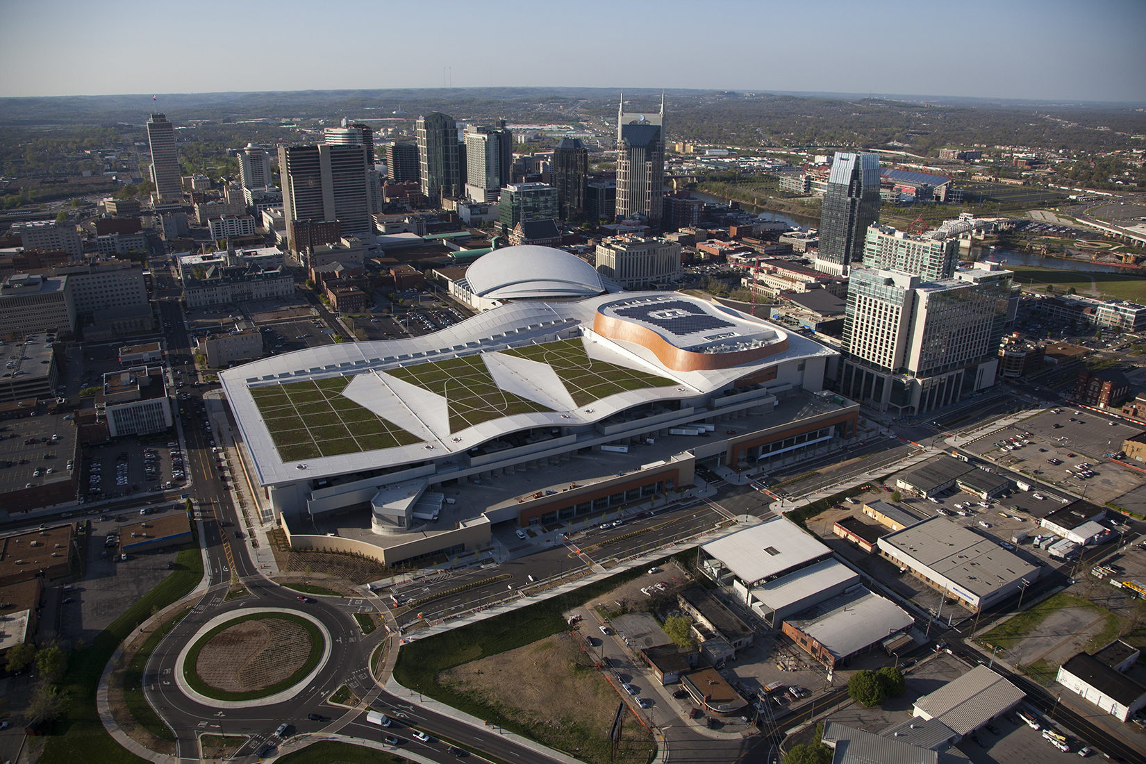
Aerial photo of Music City Center. Photo credit of Nashville Music City Center.
Proposed shortly after the economic crisis of 2008, Music City Center has been controversial since its inception. With a $623 million price tag, many felt that the 1.2 million square foot convention center would not make significant returns on initial the investment.
Mayor Karl Dean reassured Nashvillians by insisting that with resources and labor costs being low, it was not only the right time to build the convention center, but that the cost would be offset by a three mile radius ‘tax zone’ on tourist spending that would pay for the project over time.
Being a part of Mayor Karl Dean’s push to improve Nashville’s sustainability, Music City Center has a few tricks up it its sleeve which has given it LEED Silver status.On the eastern side of the building, there are 845 solar panels installed atop the roof within the shape of a guitar. The panels can supply the center with 211 kilowatts of electricity or enough to power around 45 homes.
The rest of the roof, designed to resemble the rolling hills of Tennessee, is covered in 14 different types of vegetation that change shades throughout the year.The green roof is used to reduce the amount of storm water runoff and recycle rainwater that is then used for flushing toilets and to water the exterior landscape. The water is stored within a 360,000-gallon storage tank underground.
The green roof also helps to reduce the amount of heat from the sun, thus reducing energy costs associated with
cooling Music City Center.
Omni Hotel
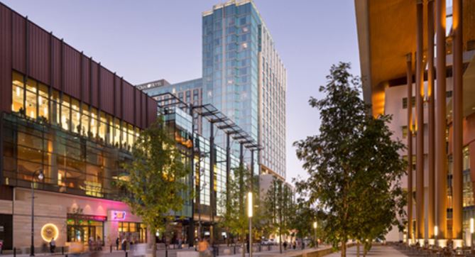
Rendering of Omni Nashville. Photo credit Omni Hotels.
Providing over 800 rooms for tourists, the 21-story Omni hotel overlooks the Music City Convention center. Met with initial skepticism as well, Omni had surpassed one million hotel room nights for the 92 events that had reserved event space before its doors opened in September 2013.
While the Music City Center has indicated signs of future success, the Omni hotel doesn’t share the same promise. Jim Murphy, a lawyer that worked with Metro on the Omni deal, stated that Omni Hotels will spend more on construction and materials than its worth upon completion.
To insure Omni Hotels would continue the project, Nashville Metro will provide $103 million in tourism taxes to Omni and a partial abatement of 62.5 percent of property taxes over 20 years. The estimated tax income lost to the city is $54 million over the life of the 20-year abatement. With its close proximity to Music City Center, it is possible that with time, even Omni Hotel can help pave the way for a prosperous Nashville.
AMP Bus Rapid Transit
As with Music City Center, Mayor Karl Dean did not waste any time improving Nashville’s transit system during the early stages of the recession of 2008. In September of the following year, Nashville’s first Bus Rapid Transit went into service on Gallatin Pike. Traveling 12 miles, service operates from Music City Central the downtown core to the edge of Sumner County, just north of RiverGate Mall.
Shortly after the successful implementation of the Gallatin Pike BRT, Plans were underway to build another route along Murfreesboro Pike. Receiving $10 million from the federal government, the Murfreesboro Pike BRT lite was created from existing bus stops by providing general upkeep, covered shelters and clocks with estimate arrival times.
The traffic lights along the BRT route were also replaced to keep the light green if busses are running behind. The same facelift was given to the BRT route along Gallatin Pike years prior increasing ridership by nearly 50 percent a month.
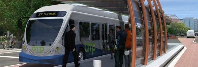
Rendering of the AMP bus station. Photo credit GoAmp.
As Mayor Karl Dean and Metropolitan Transit Authority CEO Paul Ballard spoke about the opening of the newly created Murfreesboro Pike BRT lite route, public attention had already moved onto an even bigger project—the proposed AMP BRT. Talks began in 2009 and federal funding to examine the best type of solution for a roadway followed. Come 2010, the AMP was taking form.
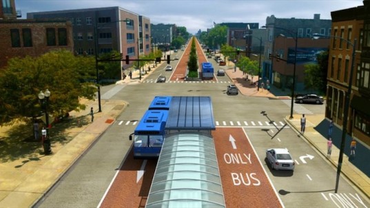
By the end of 2011, the MTA’s alternatives analysis had examined multiple types of transit services such as Bus Rapid Transit, Urban Streetcar, and Commuter Rail for the corridor. After much research, consultants recommended BRT as the best solution because of its ability to promote high ridership for half the cost of urban streetcars. By January of 2012, it was approved by the MTA Board of directors and ready for further analysis of AMPs benefits and impacts on the community.
After engineers created a mock-up of the proposed route running from Five Points in East Nashville to Saint Thomas hospital in West Nashville. The estimated cost for the route came in at $175 million, or $25 million per mile, for the seven mile bus rapid transit route. The proposed route would allow residents and visitors alike to move along the corridor faster than a car would be able to during peak traffic times.

Proposed AMP bus rapid transit route. Photo credit Metropolitian Transit Authority.
The proposed Broadway/West End BRT route does not come without its drawbacks mainly effecting those who have personal vehicles. Two lanes along the route will be sacrificed to create two bus-only roads and passenger stations in the center lanes. For the safety of pedestrians, sixteen new pedestrian lights will also be added along the route creating minor delays for other vehicles.
As well as the center lanes, on-street parking along the AMP route will be removed to provide room for the BRT and vehicles alike. With Nashville still being a car centric city, residents fear that the route will create traffic instead of alleviating an already congested city. These concerns have not halted the progress of the proposed AMP bus rapid transit route.
In March, the Federal Transit Administration (FTA) notified Mayor Karl Dean the Amp has been recommended to receive $27 million in President Obama’s proposed FY 2015 budget. Although this is a portion of the requested $75 million in federal aid, the rest is expected to be awarded multiple time over consecutive fiscal years.After the news of receiving funds from the Federal Transit Administration, it appeared the AMP bus rapid transit route would begin construction in 2015 without issue—almost.
Twenty-three days later the Tennessee Senate attempted to outright ban any kind of Bus Rapid Transit construction in the state. The ban aimed to block any form of mass transit project that would unload passengers in the center lane as well as restrict the creation of dedicated transit lanes.
Rendering of center lane BRT station. Photo credit inhabitat.com
The main lobbying behind the senate bill came from Americans for Prosperity, a national organization supported by high-profile brothers David and Charles Koch, which works to fight any sort of government spending with little regard for studies that show the benefits of state investment.
Their hand was not as strong in the lower chamber, as one month later the Tennessee House conferenced the Senate’s short-sighted bill with a much more sensible one. Although the House’s rewritten bill allows the use of center lanes and dedicated transit lanes, all similar future projects must get approval from the state legislature whether or not it receives state funding. The revised bill may cause issues with future transportation projects, but dramatically less than the Senate’s original draft.
If all continues to sway in favor of Mayor Karl Dean and the residents of Nashville, the AMP bus rapid transit route should begin construction in 2015 with service beginning in 2016.
First Tennessee Park
Nashville is home to a wide range of sports franchises, including the Nashville Predators of the NHL and the Tennessee Titans in the NFL. Soon enough, Nashville’s minor league baseball team will have a brand new ballpark to compete with the likes of the Titans and Predators.
Sounds First Tennessee Bank ballpark rendering. Photo credit First Tennessee Park.
With talks beginning in August of 2013, the ballpark was proposed by none other than Mayor Karl Dean. First Tennessee Park will serve as the replacement for the Nashville Sound’s current ballpark Herschel Greer Stadium where the team has been since 1978. Mayor Dean has said that when the new stadium is completed, the current ballpark which is a part of Metro parks system, will be used in some way.
Germantown, the neighborhood where the ballpark is being built, has been receiving a lot of buzz in the past few years being cited as the ‘potential new Gulch’ which saw its rise in new development beginning around 2004. Before construction began, the location of First Tennessee Park was nothing but fenced in fields with nothing to offer and more than an eye sore.
In not only means of improving the neighborhood, the ballpark is also being built in the same location as the first ballpark in Nashville. Sulphur Dell was in operation between 1870 and 1963—93 years in total. Mayor Dean realizes the importance of its location and used it as one of his selling points.
Google Maps picture of construction site. Photo credit Google Maps.
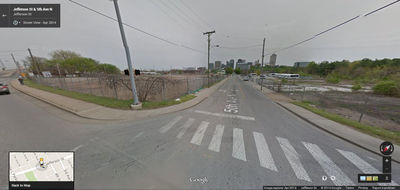
He was cited saying, “When you consider its significance in the history of north Nashville and the all-American sport of baseball, I can’t imagine a more meaningful location to give Minor League ball a new home and generate new development along Jefferson Street.”
Five months after Mayor Dean’s proposal, construction began on the new ballpark stadium January 27th 2014 and in April, Tennessee’s largest and oldest bank, Memphis based First Tennessee Bank secured naming rights with a 10-year sponsorship with options to extend for up to 10 additional years.
Having no qualms about taking on large projects, Mayor Dean stated that the ballpark would cost around $80 million upon completion. The project breaks down into $40 million for the ballpark, $10 million for a parking garage and $30 million for residential development.
The project is financed with a combination of public and private funding. Nashville will pay $65 million for the land and construction of the stadium. The stadium will be in ownership of the city and lease it to the Nashville Sounds through 2045. The Nashville Sounds have pledged to invest $50 million for mixed-use buildings and retail development to insure the economic success of the stadium. A San Antonio based development firm, Embrey Development Corp., is also building a 250 unit apartment building on site with a cost of $35 million.
With no clear sight of a definite completion time, a hopeful Mayor Dean citing the complex process involving both local and state government, said that 2015 would be the most likely completion date.
Nashville’s Future
With new and exciting development sprouting all over Middle Tennessee, there are high hopes for Nashville. Mayor Karl Dean also being a major hero for the city’s economic and transit future, seems to have no end in sight of his progressive and much needed goals.
Nashville can only hope that when residents and businesses realize the benefits of such dramatic and innovating development, they will usher in new and exciting possibilities for this big small town.
Both developments are large-scale, high impact and, instead of competing, The Banks and Over-the-Rhine offer very different options and atmospheres, providing something for everyone. Furthermore, they coalesced at about the same time which is somewhat remarkable. Both revitalization efforts had been envisioned for a long time and took years to coalesce. Various groups of people were involved in the projects, utilizing an array of strategies while facing different obstacles, yet both initiatives hit their stride at about the same time to double the impact on downtown Cincinnati.
The Banks
Aerial of The Banks Phase 1. Photo credit Cameron Knight of Cincy Beat Magazine.
Strategy Overview
- Public-investment led development
- Ballpark-oriented development
- Anchored by regional and national chains
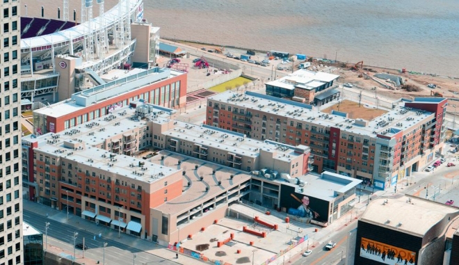
The Banks is a riverfront redevelopment project that was initially conceived in 1997 by the City of Cincinnati, Hamilton County, and the Ohio-Kentucky-Indiana Regional Council of Governments. Prior to The Banks, little existed on the riverfront as it languished in limbo without a proper vision for the area. The Banks was conceived as an 18-acre entertainment district anchored by Cincinnati’s two major sports teams: The Reds and the Bengals.
Local government initiated the investments in The Banks, believing that their efforts would pave the way for private development. By 2007, Cincinnati and Hamilton County had made significant investments in the area. First, they dealt with the Fort Washington Way (I-71/US-50), burying the freeway that disconnected downtown from the riverfront. That reduced the disruption between the riverfront and the central business district. Then the sports teams got new stadiums at The Banks – Paul Brown Stadium for the NFL’s Bengals and baseball-only Great American Ballpark for the Reds. The city and county also invested in parking garages, a transit center, a new street grid, streetscapes, and partnered with private groups on Smale Riverfront Park, according to The Banks Public Private Partnership website.
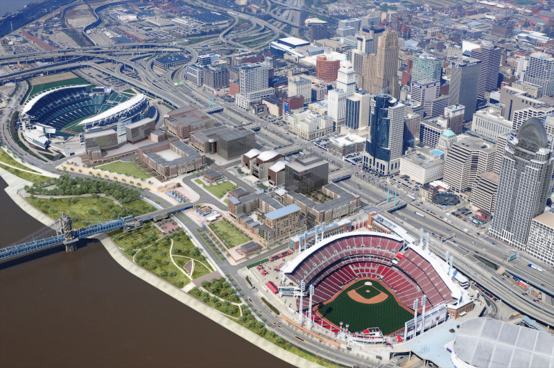
Rendering of The Banks development. Photo credit UrbanCincy.
The public-led strategy ultimately paid off. The decade-long, $128 million investment from the government prepped the area for private investment in entertainment, dining, and residential investments in The Banks. In 2008, Carter and The Dawson Company were selected as the developers to take the project over the finish line.
As construction began, it was clear what type of environment The Banks would have. Mid-rise, modern buildings in a walkable grid design connect Great American Ballpark to Paul Brown Stadium. The first floor retail spaces are large and lease structures were developed that were attractive to chains and large-scale local restaurateurs and bars. These apartments are priced at 2 1/2 to three times the city’s average.

Phase 1 of The Banks. Photo credit Schaefer Inc.
This vision is spot-on for The Banks. Phase 1, which includes 300 apartments and 97,000 sq. ft. of retail, made its first big impression on Cincinnati on Opening Day 2012 for the Cincinnati Reds. Its popularity has steadily grown ever since. There is a lengthy waiting list for the apartments and The Banks has become a vibrant entertainment center, even when Cincinnati teams are on the road.
A study completed by the University of Cincinnati Economic Center projected that Phase 1A alone will have an annual economic impact of $91 million for the region, projecting “a nearly immediate pay back on the city and county’s investment.” While I could not find the data to confirm this annual economic impact is indeed being realized, it is hard to imagine that they could have forecasted more optimistically than what has already been realized at The Banks. In 2013, the American Planning Association awarded the City of Cincinnati and Hamilton County the National Planning Excellence Award in the Implementation Category for the first phase of the development.
The Banks’ impact on downtown Cincinnati is not yet complete. Phase 2 of The Banks began in April 2014 is slated to be completed in 2015. Phase 2 will include a nine-story building that will cover a full city block, with 300 more apartments and 20,000 sq. ft. of retail space. A hotel is also a possibility in the area and The Banks’ success is drawing interest from major employers. In April 2014, GE announced that The Banks was one of three finalists to locate 1,300 new jobs in the Cincinnati region. This type of job infusion could be a game changer for downtown Cincinnati.
Regardless of which tenants end up in Phase 2, Cincinnati and Hamilton County are confident their public investment will pay dividends for the Greater Cincinnati region.
Over-the-Rhine
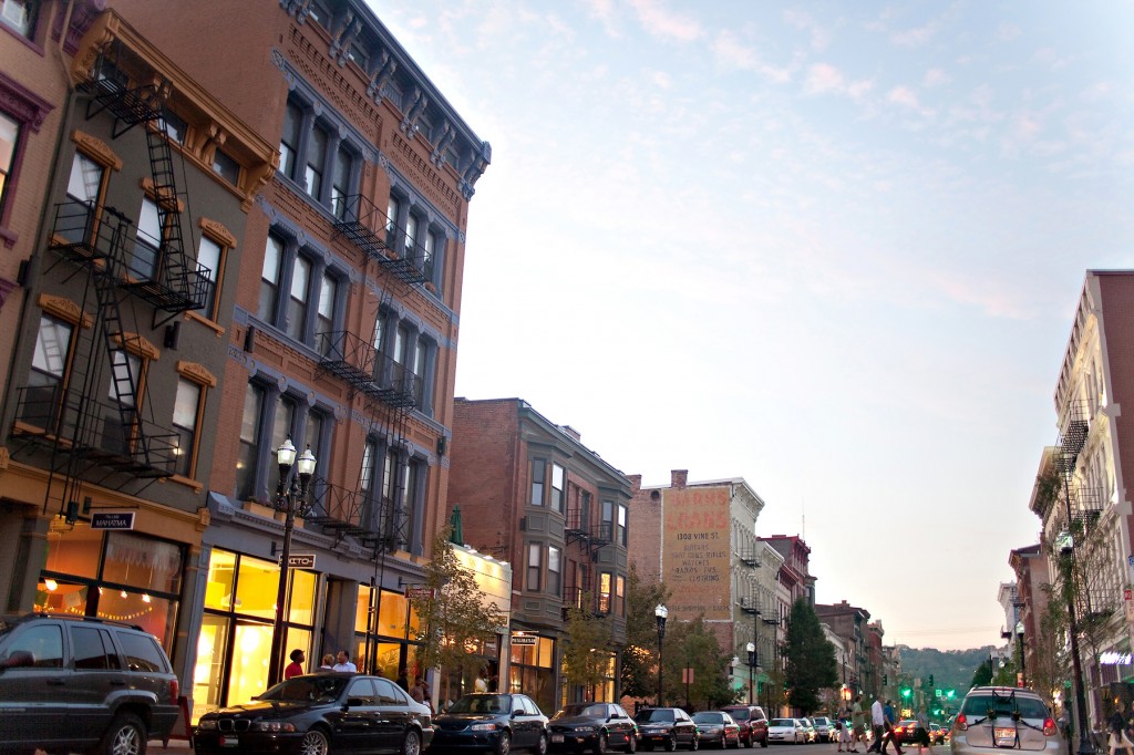
Vine Street in Over-the-Rhine. Photo credit 3CDC.
Strategy Overview
- Redevelopment Corporation master planner backed by the corporate community
- Traditional Main Street type development
- Focus on local boutiques, restaurants and retailers
While the riverfront on downtown’s south side is being transformed by The Banks, the neighborhood directly north of downtown, Over-the-Rhine, is also experiencing a renaissance. Over-the-Rhine is a beautiful 19th century neighborhood – it’s one of the largest historic districts in the country – that unfortunately has a very troubled history.
For decades, Over-the-Rhine struggled with high poverty, crime, and vacancy rates. In 2001, the neighborhood was the epicenter of Cincinnati’s race riots. Cincinnati’s leaders, both public and private, viewed the redevelopment of the neighborhood a vitally important piece of ensuring people feel safe downtown. In 2003, leaders from the city and the corporate community formed Cincinnati Center City Redevelopment Corporation, better known as 3CDC, to lead downtown revitalization efforts, and Over-the-Rhine quickly became the central focus. 3CDC became the Master Planner for the neighborhood, focusing on a 110-square block area.

110 block target area is highlighted in bright orange. Photo credit 3CDC.
From the outset, it was clear that local government would not be leading the charge, but instead play a role as a supporting player in the revitalization efforts. 3CDC has become a non-profit entity with heavy involvement from Cincinnati’s powerful corporate community, which includes household names such as P&G, Macy’s, and Kroger. This turned out to be an ideal strategy for Over-the-Rhine. Unlike the publically-controlled blank slate that became The Banks, Over-the-Rhine was a neighborhood filled with hundreds of different property owners, stakeholder groups, and troubled properties. Furthermore, its redevelopment would happen in small increments, building by building, project by project, working with different developers, architects, and stakeholders within each individual project. 3CDC has proved to be able to act nimbly and quickly – something that is often a challenge for local governments..
3CDC’s first endeavored to gain control over targeted properties. According to 3CDC’s website, there were 500 vacant buildings and 700 vacant lots in the target area. 3CDC land banked over 300 buildings and lots to take control of their future and stop the deterioration of the buildings.
Once land banking was complete, 3CDC began the redevelopment process, working block by block, utilizing creative financing – maximizing New Market Tax Credits and Historic Preservation Tax Credits. Given the character of the neighborhood, small building footprints, Main Street feel, and the reputation for being gritty, 3CDC developed unique lease structures that were attractive to local entrepreneurs with small scale restaurant and retail concepts and began apartment prices at a more moderate price point than at The Banks.
The strategy has worked well. Since its inception, 3CDC has invested $315 million in the neighborhood, leveraging local, state, and federal dollars in conjunction with private financing. 103 historic buildings have been or are being restored, resulting in 466 new and rehabilitated residential units, 155,000 sq. ft. of new and renovated commercial space, and 846 public parking spaces. 3CDC also recently completed a $48 million renovation of Washington Park, transforming the neglected public space, known as a mecca for drug deals, into a community-centered gathering place that includes a sprayground, performance stage, dog park, and event plaza.

Washington Park. Photo credit 3CDC.
Over-the-Rhine is now home to many of Cincinnati’s best new local restaurants and, according to 3CDC’s website, as of July 2013, all of the 195 completed residential units were occupied and 99 percent of the commercial spaces were leased. I have no doubt this continues to be true in May 2014.
The work in Over-the-Rhine is just getting started. 3CDC has big plans for future development in the neighborhood, including Mercer Commons, a $63 million projects including 19 buildings and 26 vacant parcels that will result in 96 market rate apartments, 30 affordable apartments, 28 condominiums, 17,600 sq. ft. of commercial space and 359 parking spaces. 3CDC is also eyeing redevelopment of 18 buildings on three other streets that would create 74 condominiums, 14 apartments, and 8,100 sq. ft. of commercial space. In December 2013, 3CDC was awarded more than $3 million in Ohio Historic Preservation Tax Credits for 8 of the buildings slated for redevelopment, moving these projects forward.

Mercer Commons. Photo credit 3CDC.
Over-the-Rhine still has a long way to go, but for the first time in many years, the neighborhood’s future is projected to grow and improve.
Conclusion
Together, these two developments have sparked investment throughout downtown. According to the 2014 State of Downtown, downtown Cincinnati developers reported completed projects totaling over $491 million in 2013 and $930 million more in projects are under construction or proposed in the central business district and Over-the-Rhine.
Perhaps just as important, perceptions of downtown have improved as well. According to an annual survey completed by Downtown Cincinnati Inc., in 2013 78 percent of respondents said that their opinion of Over-the-Rhine was more favorable than the year before and 74 percent said that their opinion of the central business district was more favorable than the year before.
As an adopted Cincinnatian after living in the region for 8 years, I am thrilled and awed by the rapid transformation that is underway in downtown Cincinnati. The change is a result of long-term dedication and hard work by local government, corporate leaders, a strong redevelopment corporation, and a laundry list of people and organizations willing to take risks on downtown Cincinnati. Do yourself a favor and experience a rejuvenated Cincinnati to check out the exciting new developments, take in a game at The Banks and head to Over-the-Rhine for some great food afterwards. You’ll be glad you did.
Angie Schmitt, a blogger for the USA Streetsblog, expanded on Krugman’s piece. A generation ago, Schmitt explained, Pittsburgh and Detroit were in a similar position, “but Pittsburgh managed to keep its central city relatively strong, while the Detroit region saw a full-scale exodus from the city core.” As a result, Pittsburgh was able to adapt the economic changes so often blamed for Detroit’s decline. “There are many factors that distinguish Detroit from Pittsburgh,” Schmitt acknowledged, “but the sprawl factor can’t be ignored.”
Sprawl is associated with a variety of issues; from high costs associated with maintaining a vast system of infrastructure to the loss of agricultural and environmentally sensitive areas. It also, as Krugman suggests, impedes social mobility by encouraging job growth on the fringe of metropolitan areas out of reach of poor and working class families in the central city and inner-ring suburbs. A study by the Brookings Institution found that “three of the five most decentralized metro areas” are Midwestern cities. Detroit tops the list with 77 percent of its jobs located in the outer ring of its metropolitan area. The distance between residential centers and employment opportunities places a tremendous burden on residents that rely on public transportation. The daily commute is a drag even for those lucky enough to own a car. Forbes previously reported that only 11 percent of Detroit’s commuting population walks, carpools or takes public transit – the lowest percentage of any major American city – leaving the remaining 89 percent of commuters languishing in the country’s second worst city for traffic delays.
The first step to recovery is admitting there is a problem, and metro Detroit has a sprawl problem.
Unfortunately, as Schmitt points out, metro Detroit also has a problem with regionalism, and regionalism is a crucial prerequisite to addressing sprawl. For a moment, let’s assume we can overcome our love of localism for the good of the region, and look at the approaches other states and regions have taken to address sprawl:
- Urban Growth Boundaries (UGBs): As the name suggests, an UGB is a boundary designed to limit urban growth. Ideally, separating urban and rural land, or land that is developed from land that is not and should not be developed, such as agricultural zones, nature areas and public land. Like in Portland? Yes, exactly like Portland.
- Urban Service Limits (USLs): USLs are very similar to UGBs. Essentially, an USL is a boundary beyond which governments don’t provide services like water and sewer. A municipality, county or region can choose to enact an USL to discourage developers from building outside already developed areas. Freeport, Florida offers an example.
- Priority Funding Areas (PFAs): A PFA is an area given priority by the state when it comes to funding and support for development. PFAs have considerable appeal because they represent a minimal intrusion into municipal land use—a benefit in states with a fractured system of local government like Michigan. Maryland has successfully utilized PFAs since 1997.
- Transfer of Development Rights (TDR). TDR policies can assuage concerns about losses in land value, which are frequently raised in response to the above-mentioned tools. In short, developers who hope to build in an already developed area purchase rights from individuals whose properties are in protected, or limited growth areas. King County, Washington is one of many places utilizing TDR.
Again, metro Detroit’s addiction to sprawl is a drain on the city and its region. In order to strengthen the regional economy as well as local communities, it is becoming increasingly evident that growth management strategies are necessary. This will help protect property values, increase density for those who choose to live near the urban core, and create vibrant, walkable communities which can be better served by effective transit systems. That said, any of the above-mentioned anti-sprawl strategies would require action at a greater-than-local (regional or state) level.
The good news is that governor Rick Snyder’s administration recently introduced its Regional Prosperity Initiative (RPI), which is reminiscent of Maryland’s PFA program and may be a step in the right direction. The RPI is a “voluntary competitive grant process” that recognizes regions that collaborate in the creation of a vision that addresses redundancies and gaps in service delivery. The voluntary aspect of the program allows the state to encourage regional planning while sidestepping much of the criticism often associated with government intervention. RPI compliments the state’s existing Economic Vitality Inventive Program (EVIP); both tie municipal funding to a local community’s ability to coordinate service delivery with its regional neighbors.
EVIP and RPI encourage dialogue between municipalities and regional cooperation. That is a good thing. However, both programs seem focused on identifying cost-savings through the elimination of redundant services and the consolidation of existing boards and commissions. Neither program acknowledges the role sprawl plays in increasing the cost of delivering services or highlights the economic benefits associated with density. The ability of municipalities to opt out of Michigan’s RPI may also prove to be its undoing. It is difficult to plan regionally without the participation of the entire region.
Despite its shortcomings, RPI seems a logical first step given Michigan’s traditional unease with centralized planning – especially in metro Detroit. The stipulations attached to the RPI’s funds should act as a carrot that encourages organic regional planning, instead of a stick that would likely encourage backlash. The key question becomes, will Michigan’s RPI evolve into something similar to Maryland’s robust, attractive incentive program? Will the governor’s RPI actually influence development patterns in the state and have its intended, positive impact, or will it become an example of a failed attempt to combat sprawl? Will metro Detroit come together or will it see RPI funds directed towards other – more cooperative – parts of Michigan? I guess we’ll have to stay tuned.