The ruling stated that the city is financially insolvent, unable to create a roadmap for paying off the estimated $18 billion in debt with existing revenue streams. Rhodes agreed with Orr that the city had attempted to negotiate in good faith with creditors. Detroit Emergency Manager Kevyn Orr had made attempts to reach out to creditors and give them tours of the city in order to show them the dire situation of dilapidated infrastructure and crumbling housing stock. The idea was that the creditors would take settlements of pennies on the dollar owed after seeing the shape the city was in. Creditors however, were not interested. With over 1,000 creditors requiring agreements to be reached, it simply could not materialize.
Rhodes also ruled that the challenges to Detroit’s Emergency Manager law were moot and that the authority of the Emergency Manager allowed for the city to enter into bankruptcy without approval of the mayor or city council.
Orr said of the ruling in a statement:
“We are pleased with Judge Rhodes’ decision today, and we will continue to press ahead with the ongoing revitalization of Detroit. We look forward to working with all our creditors – pension funds, unions and lenders – to achieve a consensual agreement on a restructuring plan that balances their financial recoveries with the very real needs of the 700,000 citizens of Detroit.”
Many remain concerned over the future of both city assets (particularly the Detroit Institute of Arts) and the pensions of city employees, which Rhodes ruled today were not protected by the Michigan State Constitution. While pensioners await their fate, citizens wonder if there will be a fire-sale of non-essential assets in order to pay off creditors. It is expected that we will have a better idea of what will become of Detroit’s assets by 2014, when Kevyn Orr and Mayor Dave Bing’s administration unveil a debt reduction plan while under bankruptcy protection.
This will have larger implications outside of Detroit, as the ruling that private pensions are, according to Rhodes, “not entitled to any heightened protection in bankruptcy.” This essentially means that as far as federal court is concerned, pension debt is no different than any other form of debt liability. While Detroit is the biggest US city to file for bankruptcy, it certainly is not the first. With employee pensions no longer immune to insolvency, this could have implications from Camden New Jersey to Vallejo California.
We can only hope that these initial and painful steps will pave the way for a better Detroit in the future.
An appeal was filed almost immediately by the American Federation of State, County and Municipal Employees Union.
Update: Dec 3, 2013 at 2:56pm
In a statement today, Detroit’s Emergency Manager Kevyn Orr says that the artworks in the Detroit Institute of Arts is valued at less than $2 billion. Selling or leasing the art, while still on the table, will not solve the city’s financial obligations including a $3.5 billion pension shortfall.
With the embattled mayor’s term expiring, the city officially elected City Councilman Bill Peduto to replace him. While the new mayor will not take over the position until January, Pittsburgh urbanists have much to be excited about in the mayor-elect. His priorities read like a laundry list of urbanist dreams: a subway connecting downtown and the city’s cultural district, a new city Bureau of Special Projects that will undertake transformational initiatives in city neighborhoods, and complete street renovations in key corridors downtown. Most telling for the mayor-elect, however, has been his focus on improving development patterns.
Demanding Better Development

Image from Almono.org
Even before taking office, Peduto has challenged some of the largest developers in the city to ensure quality urban development. Three massive redevelopment projects are close to breaking ground: a massive brownfield redevelopment named Almono, the construction of a new urban neighborhood on the site of the Pittsburgh Penguins’ former Civic Arena, and a mixed-use riverfront development in the city’s Strip District.
While the Almono project (named for the city’s three rivers—Allegheny, Monongahela, and Ohio), already aimed to be a large, mixed-use, urban infill project, the mayor-elect challenged the non-profit developers to improve the development by more thoroughly addressing water-quality issues, a major problem in the heavily urbanized city. The mayor-elect’s solution? Invest in a series of canals throughout the development that would not only hold storm water before releasing it into the area’s rivers, but also improve the aesthetics of the proposed community.
At the Civic Arena site, Peduto directly challenged the developers when they asked for additional tax incentives and investments from the city. Rather than offering up no-strings-attached funding, Peduto demanded that infrastructure money be invested in better connections to nearby struggling and largely African American neighborhoods. Through this effort, Peduto is making good on long-overdue promises to these communities, particularly the Hill District and Uptown, two places promised large returns when urban renewal initiatives first demolished large swaths of the neighborhoods for construction of the Civic Arena.
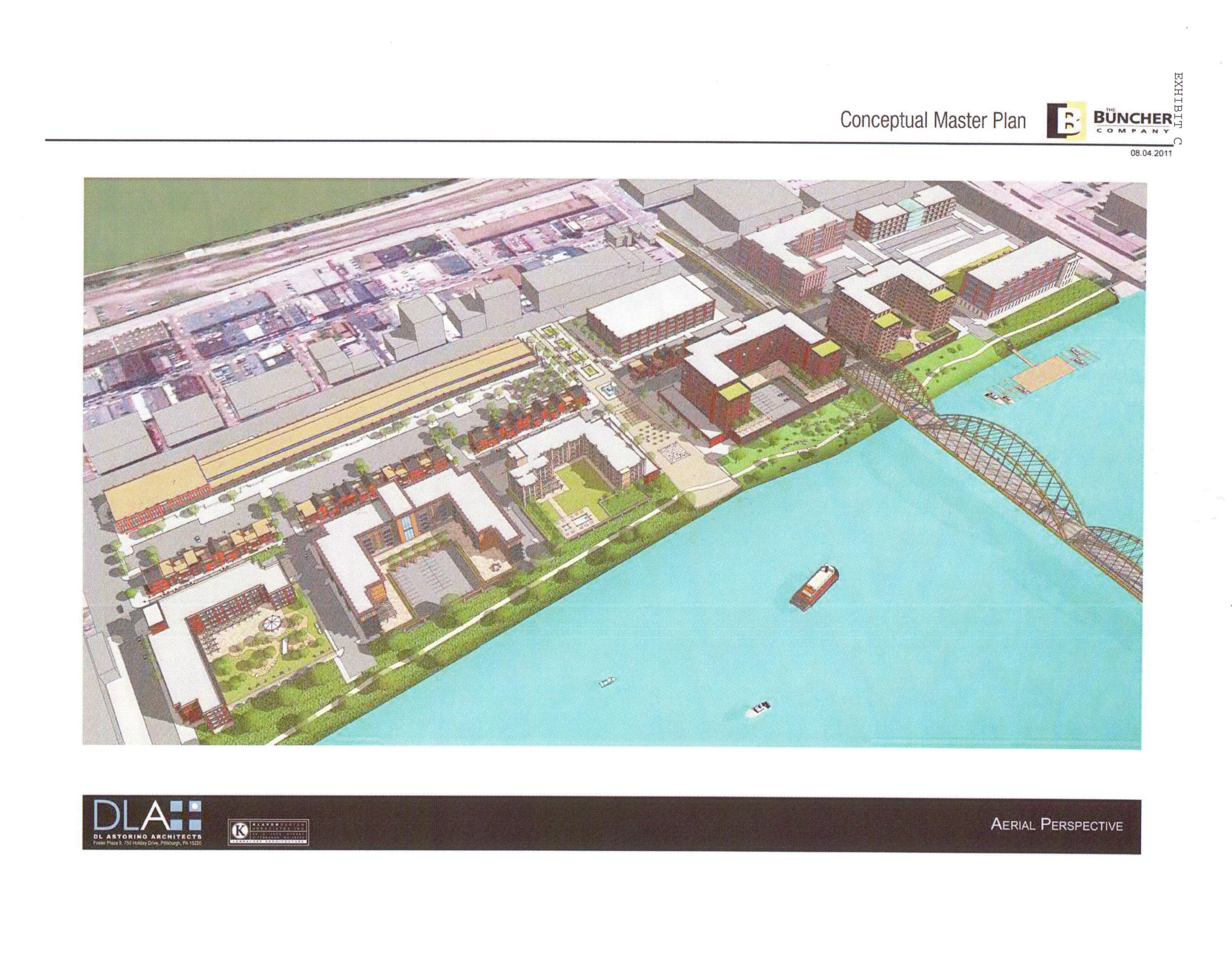
Image courtesy of pittsburghpa.gov
Finally, the mayor-elect’s last foray into development initiatives has been in the city’s historic Strip District—a wild cluster of butchers, grocers, and neighborhood markets reminiscent of turn-of-the-century market districts. The longest building in the area is the Produce Terminal, a historic structure that once housed numerous wholesale fruit and vegetable distributors. The massive rail yard that once fed the Produce Terminal, however, has largely been paved over, and developer Buncher Company bought the site for a mixed-use development. Urban design critiques notwithstanding—and there are many—the major source of citizen complaints with the project has been Buncher’s proposal to demolish a third of the historic Produce Terminal and rehabilitate the remainder for better access between the new development and the shops of the Strip District. As mayor-elect, Peduto is seeking to disassociate the Produce Terminal from the larger development, thereby saving the building from partial demolition.
A Brighter Future for the Steel City?
With the election of Councilman Peduto, the Steel City has made a choice for a more progressive mayor who is willing to fight for better development. Whether the mayor will be successful in altering development patterns, and to what extent he will be able to accomplish his other priorities is unclear, but for now, urbanists have reason to celebrate in Pittsburgh.
In a press release issued today, the Department of Housing and Urban Development says:
“Through this investment, HUD is providing the resources for local leaders to transform neighborhoods into thriving communities where families will choose to live,” said Donovan. “The Choice Neighborhoods Initiative represents the next generation in a movement toward revitalizing entire neighborhoods by providing critically needed funding to support locally-driven economic development solutions in these areas. I look forward to working with these cities and communities as they work to build stronger neighborhoods for all.”
The following communities will be receiving grant money:
- Mills Memorial/Central Business Neighborhood (Meriden, Connecticut)
- Melrose East – Smiley Heights (City of Baton Rouge/Parish of East Baton Rouge, Louisiana)
- Sun Valley (Denver Colorado)
- Los Angeles Choice Neighborhood (Los Angeles, California)
- Greater Five Points (New Bern, North Carolina)
- Sharswood/Blumberg (Philadelphia, Pennsylvania)
- Upper Land Park – Broadway (Sacramento, CA)
- North Wellston Choice Neighborhood (Wellston, Missouri)
- Cleveland Avenue Neighborhood (Winston-Salem North Carolina)
The grant money will be used by the awarded organizations to work with their partners, planners, stakeholders, and the public to bring fourth public housing and neighborhood revitalization efforts. Many these areas are near downtown cores, and have numerous assets that, if leveraged correctly, could continue to grow and strengthen neighboring areas.
On the agenda for many includes the redevelopment of public spaces and the addition of mixed-use buildings as well as increased access to better public education and transportation.
You can read the detailed plans here. Click here to learn more about the HUD Choice Neighborhood Planning Grants.
]]>A criteria and methodology has been applied for determining a city’s reputation, with performance indicators broken down into three “dimensions”: appealing environment, advanced economy, and effective government. Cities that were well balanced between these three dimensions and performed well in all of them were the ones with the higher reputation. Positive signs in these areas mean that people would recommend living in, visiting, working in, investing in, or buying products or services from this city. Everything was applied to a point scale out of 100.
With a score of 77.3, Sydney, Australia took the top spot. With over four and a half million people advocating for living, working, and doing business in Sydney, the city finally surmounted third place, a position it held for the past two years. First place was overtaken from Vancouver, Canada who held the title in 2012 and London, England in 2011.
London was absent from the top 10 of 2012 as Vancouver is absent from the top 10 in 2013 (in 2013 however, London returned at number 9). This highlights how competitive the standards are, as well as how close all members of the top 10 are in relation to each other. It is unclear how much current events play in the overall reputation (both enhancing and damaging). The successful 2012 olympic games may have helped London get back into the top 10. However recent issues surrounding Toronto’s Mayor Rob Ford will affect the city’s reputation in the future and may cause it to disappear from the list in 2014.
Even though Sydney scored the highest overall, they did not finish in first place for any of the three performance indicators. Rome took top place for highest reputation in appealing environment (80.9), New York for advanced economy (87.7) and Zurich for effective government (75.1).
In terms of actual supportive behavior, which is led by perception, these cities took the top spots:
- Venice, IT – Best city to visit (86.5)
- New York, US – Best city to invest in (70.6) or to buy from (74.0)
- Toronto, CA – Best city to work in (73.6)
- Sydney, AUS – Best city to live in (74.7)
The cities with the greatest improvement in overall reputation from 2012 were Moscow, Russia with an 11.8% improvement, Toronto, Canada with an 11.5% improvement, and Amsterdam, The Netherlands with an 11.2% improvement. The negative evolution was greatest in Nairobi, Kenya with -12.7%, Caracas, Venezuela with -10.5%, and Tehran, Iran with -9.4%.
The complete top ten is as follows:
- Sydney, AUS 77.4
- Toronto, CA 76.9
- Stockholm, SWE 76.9
- Vienna, AUT 76.9
- Venice, IT 75.8
- Florence, IT 75.8
- Edinburgh, UK 75.1
- Zurich, SW 74.7
- London, UK 74.4
- Copenhagen, NED 73.0
With only 4.4 points separating the top ten, we can see that these are all cities which have a well rounded approach an execution to local government. They excel in not only creating a place where people want to live, they have local governments that are effective in putting good policy into action.
The full report from the Reputation Institute contains the top 100 G8 countries by reputation as well as greater breakdowns of the methodology used to determine these numbers. You can download the report, and other helpful reports, at the Reputation Institute’s website.
Cranley, a Democrat and former councilman, made his opposition to the project a central point of the campaign, and many feel that it was the biggest difference between him and his opponent Roxanne Qualls, the current Vice Mayor who favored the project. Cranley criticized the streetcar and felt that costs had been problematic. The city already has over $20 million into it with over $90 million in contracts that are expected to complete the street car in 2015 or 2016. Track has already been laid, as workers have continued to do until ordered to stop. If Cranley makes good on his promise, it’s not sure what will happen to either the current rail infrastructure or the financial obligations the city is under contract to uphold. It is curious to see what the liabilities of the city will be, and it turns out they may be on the hook for quite a bit of that $90 million owed to contractors.
This isn’t the first big government project that has come under fire for going over budget. Recently, out of control costs on a county jail in Detroit Michigan forced Wayne County to abandon the project and sell the land – a prime location in Detroit’s rapidly growing downtown – to Quicken Loans Developer Dan Gilbert, who will purchase the land and the partially complete jail. The difference here is that there is nobody who you can sell partially finished rail infrastructure to. Even for a private party to be interested in running a fully independent streetcar project, you would need better infrastructure in place than what is currently there. Los Angeles has faced similar issues, dishing out over $500m in the past couple years for their streetcar project which has also (you guessed it) far surpassed its budget. With no real way to sell the investment and gain anything back, the fiscal logic of Cranley seems to be that we either take a big loss now, or a much bigger loss later.
This is a microcosm of a problem happening across the country as project costs either spiral out of control, or are so poorly projected that the actual cost is nowhere near the projected cost. For a long time, this was simply considered part of doing business: the politicians need to make good on their promises no matter what, so the contractors have little incentive to accurately predict costs if they know that if they come back later and ask for more money, they will almost certainly get it.
The decision hits home especially hard for the people of Cincinnati as we approach the 100the anniversary of the abandonment of the city’s subway system. In that case, the inflation brought on by World War I had more than doubled the cost of construction, and the project was simply out of reach. To this day there exists an interested network of underground tunnels that have been sealed off leading to the subway, which has been called the city’s biggest failure.
We won’t know for sure until after December first, but with a new mayor and six of the nine members of city council now opposed to the street car initiative, it looks like another failed transit project for the crown jewel of southern Ohio.
Update: November 9, 2013
The Twitter account @CincyStreetcar posted this image, estimating the cost of turning down the streetcar project is now over $100m, while the cost to complete the streetcar is around $133m.

Estimated cost to cancel the streetcar.
The new tunnel is over 13km long and cost €3bn to put into place (€1bn of which was paid for by Japan). The tunnel sections were dropped in from above instead of dug out, and sit 55m deep. Like most large infrastructure projects, this one was far behind schedule – about 4 years. The reasoning is different, as important archeological discoveries were made during tunnel construction which required special care to be removed in order for the tunnel to be completed.

Map showing the location of the Marmary Tunnel.
The hope is that with the Marmary tunnel, Istanbul will be able to relieve traffic congestion by allowing 1.5 million people to commute without using one of the two bridges to the north. Istanbul is Europe’s biggest city at around 15 million people, 2 million of which cross the Bosphorus straight every day. While the tunnel is not expected to be a complete solution, the fact that the trains currently serving the tunnel can carry 75,000 people in either direction each hour is impressive by any standard. In the future, the plan is to allow freight as well as high-speed rail lines to cross as well. This will link six existing suburban lines with a line that takes commuters right into the southern side of Istanbul.
Five of the 37 stations have opened to kick-start the project which while has been unveiled is far from complete. Having lost their bid for the 2020 Olympic Games, Istanbul was looking for a way to put themselves back into the world’s spotlight. With this project, they might be on their way. The dream of being able to hop on a train in Tokyo and head to London is now a little bit closer to reality.
In many areas of Europe, car sales have been sluggish, but some data does suggest a recovery. That recovery might tip the scales in favor of the automobile in countries such as Spain where bicycle sales and automobile sales were very similar. That is of course if they can convince the younger generations to get on board with car purchasing despite the numbers that show millenials are buying fewer cars, driving fewer miles, and putting off getting a drivers license (assuming they ever do).
From across the pond, the Euro car market looks somewhat ridiculous. When we see headlines that proclaim that the Tesla S is the best selling car in Norway, we start to wonder how close things actually are in the United States to what happens over there.
But in the United States, there have only been a few years in the past 20 where automobile sales have surpasses bicycle sales as the char below shows.

Car and Truck vs. Bicycle Sales in the US. 1992-2012
We can see that even in 1992, bicycles outsold new cars and trucks (it is worth noting that this includes car and truck passenger vehicles. Motorcycles are not included but their figures can be anticipated at each year at less than 500,000 unites sold and as such do not create a substantial gap closure in most years on the chart). In fact, the recession saw a large drop in both bicycle and car sales in 2008. Despite this, bicycles recovered much more quickly and saw in 2010 a disparity of almost 8 million more bicycles sold in the United States than cars.
Considering the number of european countries who have invested and will be investing more in infrastructure for both cycling and public transit, we can expect the european disparities to increase, favoring the bicycle over time. Most American cities have been slow to adopt dedicated bike lanes and other transit policies that favor modes of transportation other than the automobile, yet despite this we can see that the free market has clearly spoken: cars and trucks have not outsold bicycles in the United States for over 10 years and that shows no sign of changing.
]]>Their press release indicates key findings from the report:
- Process is equal to the outcome: The community engagement necessary in the organizing, deliberating, communicating, building, programming and maintaining of public places has an equally important benefit for communities as the physical outcomes. In short, the “making” of public places builds social capital and enhances community capacity for action and leadership.
- Placemaking creates a virtuous cycle: The relationship of places and their communities is not linear, but cyclical and mutually influential. Places grow out of the needs and actions of their formational communities, and in turn shape the way these communities behave and grow. This mutual influence of community and place creates a virtuous cycle of placemaking that supports the mutual stewardship of place and community and the creation of civic infrastructure necessary for healthy societies and collaborative problem solving.
- Public places are never “finished:” The iterative and interactive process inherent in the placemaking cycle creates multiple entry points for a wide variety of actors and actions; the engagement of community members, funders, advocates and public officials supports an expanding view of “community” and creates a foundation for positive change and healthy communities.
- Temporary initiatives and tactical methods can be remarkably effective: Placemakers are adopting tactical methods that are low-cost, flexible, temporary and sometimes unsanctioned over permanent and costly bricks-and-mortar projects. Tactical methods such as the creation of temporary installations that host pop-up businesses, reclamation of parking spaces for human use and enjoyment, and reallocation of roads for walkers, runners, and cyclists, can be remarkably effective in remaking a public space quickly and cheaply while calling attention to the need for better placemaking on a larger scale.
- Placemaking is open-source: The democratic ethos of the movement and the “trickle-up” nature of tactical placemaking demonstrate the growing influence of an Internet-influenced model where positive change can happen in real time and everyone is empowered to be a maker.
- Public/Private partnerships elevate what’s possible: The growing prevalence of public/private partnerships in the practice of placemaking reflects new types of cross-disciplinary collaborations that mirror the complexity of communities and the issues faced. These partnerships often mix regulatory power and public ownership with private resources and efficient management to create and maintain well-run places that would not otherwise be possible.
You can see the full press release on the PR Newswire website here.
The following places were used as placemaking case-studies for this white paper:
- Corona Plaza: Queens, NY
- Better Block: Norfolk, VA
- Guerrero Park: San Francisco, CA
- Precedent Mini-Case: Project for Public Spaces©, New York, NY
- Eastern Market: Detroit, MI
- Precedent Mini-Case: Bryant Park, New York City, NY
- City Repair Cleveland: Cleveland, OH
- Shreveport Common: Shreveport, LA
- Fargo/Moorhead StreetsAlive: Fargo, ND and Moorhead, MN
- TAXI: Denver, CO
- Precedent Mini-Case: Playborhood, Menlo Park, CA
- Kentlands: Gaithersburg, MD
- Discovery Green: Houston, TX
While each of these case studies presents unique challenges and has a unique set of goals, I came away with a central thesis that can define the entire report. It was from the Shreveport Common section where it talks about using art and culture as the driver for placemaking. While much talk in the world of planning revolves around the big urban centers in the US like Los Angeles and New York or the “Up and Coming” metros like Ft. Collins or El Paso, we don’t often hear about anything that happens in Shreveport. By any objective standard, it’s not where the families, hipsters, or yuppies are looking to relocate to in order to make a better life for themselves. After hitting its peak population of 205,000 people in 1980, Shreveport is now hovering around 200,000 people making it America’s 108th largest city. But the lesson here is that you don’t need blatantly recognizable city skyline, foundation money, expensive public-private partnerships, or an influx of millennial creative class baristas to make placemaking work. You just need a few things: Community and leadership.
Placemaking doesn’t need hot-market cities and young urban professionals to be successful: it just needs committed leaders and an enthusiastic community
You can download the entire report in PDF format here.
The incorporated non-profit’s “4 pillars of sustainability”, ecological, social, cultural and economic sustainability, are prevalent in the goals and principles of the charter. While this is a non-binding document, it recognizes the challenges of Canada for the years ahead and gives planners and city officials a way to look forward to see if their goals are in line with the direction Canada is moving in.
The following is a transcript of the document, which you can also view in PDF format by clicking here to download the Halifax Charter.
The Charter for Canadian Urbanism (The Halifax Charter)
A MISSION & MANDATE FOR THE COUNCIL FOR CANADIAN URBANISM
OUR MISSION
THE COUNCIL FOR CANADIAN URBANISM IS DEDICATED TO IMPROVING CITY-BUILDING PRACTICES, RESEARCH, AND EDUCATION IN ORDER TO CREATE SUSTAINABLE, HEALTHY AND LIVABLE CITIES AND COMMUNITIES ACROSS CANADA.
WHO WE ARE:
The Council for Canadian Urbanism, or “CanU,” is a movement of passionate and dedicated practitioners in Canadian city-building, supporting each other across the country and making real contributions for progressive change. We think and work collaboratively across disciplines for a comprehensive, holistic and multi-disciplinary urbanism.
CanU brings together leading city planners, urban designers, architects, landscape architects, engineers, developers, politicians, civic leaders and other multi-disciplinary urbanists from across Canada. Initially emphasizing urban design and physical city-building leadership within city governments, the private sector, the community sector and academia, CanU continues to evolve to encompass all aspects of successful city-making.
THE MEMBERS OF THE COUNCIL FOR CANADIAN URBANISM SHARE A SET OF:
COMMON BELIEFS
Canadian Urbanism and Canada’s future
There is a distinct Canadian Urbanism, a shared approach and perspective to cities and city-building evolving over time within our constitutional, socio-political and cultural history, and shaped by our landscape and climate. Canadian cities and communities share challenges and opportunities unique to our country. At the same time, Canadian Urbanism shares characteristics and challenges in common with progressive urbanism movements in other countries and global regions.
Canada is increasingly both an urban and suburban society. Within our special context, we have built some of the world’s most livable cities and have pioneered smarter suburbs, but we have also built costly and unsustainable urban sprawl. The success or failure of Canada depends on the success of our cities and communities.
Canadian Urbanism and Canada’s challenges
Canada’s cities and communities urgently require more progressive and creative approaches in order to become more successful, sustainable, creative, livable, healthy and resilient. Implementing a better Canadian Urbanism is key to addressing our most critical challenges, including climate change, ecological integrity, economic health and global competitiveness, energy resiliency, affordability and homelessness, public health, and social inclusiveness.
Canadian Urbanism is “by design”
A successful Canadian Urbanism recognizes the integral value of urban design and progressive physical city-building influenced and informed by our ecological, social, economic, historic and cultural values. Urban design must succeed at all scales: regional, city, community, neighbourhood, street, block, site, building and public realm. It must be shaped by city and municipal vision, private sector expertise and innovation, and meaningful community engagement and leadership.
Great change is needed and possible
To rapidly realize a more progressive Canadian Urbanism, great change is required. Greater learning, experimentation and the will to challenge the status quo are necessary. Candid dialogue and constructive debate is essential, and must result in meaningful action.
COMMON PRINCIPLES
The four pillars of sustainability
Canadian cities must urgently strive for ecological, economic, social and cultural sustainability as the primary goal of city-building.
A new Canadian urban model
Canadian cities must implement a consistent and persuasive new urban model, with corresponding approaches, standards and tools. This model is based on complete, compact, mixed-use, inter- connected, and vibrant neighbourhoods that prioritize sustainable and healthy mobility choices – walking, biking and transit. This new model will replace the unsustainable, use-separated, low-density, car-oriented model of the past.
Regionalism, diversity and authentic sense of place
Canadian Urbanism is based on respect for regional identity and authenticity, with city-making that captures the unique spirit and diversity of Canadian communities from coast-to-coast.
Flexibility, resilience and designing for change
Effective city-building anticipates and allows for adaptation to ever- changing conditions and challenges. It is dynamic, not static. It avoids over-prescriptive solutions to complex urban issues.
Professional integration and silo-breaking
Collaboration and a shared engagement between the design professions is essential to successfully address our urban challenges. Together, we will champion the further dismantling of specialist approaches to complex urban issues, or “silo-thinking”, in favour of a more holistic approach.
City leadership and community collaboration.
Municipal governments must take a leadership role in shaping city design at every scale to meet public needs and challenges. Such leadership is built on the strong Canadian tradition of engaged community dialogue in city-building, and a shared understanding of market needs and innovation opportunities with builders and developers.
COMMON OBJECTIVES
To Create Change
We will champion change and promote a new urban model for Canadian Urbanism locally and nationally, with the development of new tools and best practices, and shared learning among cities and communities across Canada.
To Lead
We will be a unified, multi-disciplinary leadership voice in the national dialogue and decisions affecting the future of our cities, and the quality of city-building in Canada.
To Advocate
We will champion an improved quality of urbanism and urban design across Canada, and support each other’s efforts within government, the development industry, communities, media, and education.
To Educate
We will foster learning and discussion about Canadian Urbanism, through public discourse, media, writing, research, teaching, and university curriculum-building.
To Convene
We will bring together forums, virtual and physical, among urbanists from diverse perspectives and across professional barriers, to address outdated urban models and support a progressive Canadian Urbanism.
The Charter for Canadian Urbanism was signed on September 29, 2013 in Halifax, Nova Scotia.
 Living Labs Global jointly with 21 global cities has announced a shortlist of over 100 innovative, citizen-centred and sustainable technology solutions selected from 555 entries to the Living Labs Global Award 2012. Nominated solutions meet challenges covering areas such as Affordable Housing, Prevention of Obesity, Transport & Mobility, Tourism, Access to the Knowledge Society and Inclusive Governance, to improve the lives of 110 million citizens in these 21 cities in four continents. Winners will be announced at the Rio Summit on Service Innovation in Cities on 2-3 May 2012, bringing together leaders from visionary cities and pioneering entrepreneurs.
Barcelona (Spain)/Copenhagen (Denmark), 5th March, 2012 Today 21 global cities jointly with Living Labs Global, partners Citymart, Oracle and The Climate Group have announced the results of its first round evaluation of 555 entries received from 55 countries, which was carried out by an international expert jury as part of the Living Labs Global Award 2012.
The 109 shortlisted solutions have been announced here: http://llga.org/nominated
Shortlisted companies and organisations are now invited to provide in-depth supporting information, leading to the announcement of the winners at the Rio Summit on Service Innovation in Cities on 2nd May, 2012.
The winners of the 21 city categories of the Living Labs Global Award 2012 will be invited to carry out a full-scale pilot in the cities, to evaluate impact, provide input into product development, and improve procurement or regulatory decisions by cities later on. This has transformed the way waste management is planned in Barcelona, the way venture capital is provided to social entrepreneurs in Cape Town, or community healthcare is delivered in New Taipei City.
Councillor Paul Tilsley, Deputy of Birmingham City Council (UK), one of the 21 participating cities, which is seeking solutions for waste management, said “We think the Living Labs Global Award is a real opportunity to help find an innovative solution, fully utilising emerging technologies to efficiently and effectively process food waste, resulting in a sustainable energy source for the benefit of Birmingham business and residents.”
About the Living Labs Global Award 2012:
Living Labs Global, a non-profit association based in Barcelona and Copenhagen promoting digital service innovation in cities, is organising the 2012 edition of the Living Labs Global Award in cooperation with the Cities of Barcelona, Birmingham, Caceres, Cape Town, Coventry, Derry~Londonderry, Eindhoven, Fukuoka, Glasgow, Guadalajara, Hamburg, Lagos, Lavasa, Kristiansand, Mexico City, Rio de Janeiro, Rome-Lazio, San Francisco, Sant Cugat, Santiago de Chile and Terrassa to choose the companies and organizations that have developed solutions that add high
value to users in cities around the world with the aim of helping over 110 million citizens in the Americas, Africa, Asia and Europe.
The Award is organised in partnership with Citymart, Oracle and The Climate Group, with winners being presented during the Rio Summit on Service Innovation in Cities, at which 4 experts/journalists will moderate discussions among the 21 cities and over 100 shortlisted companies will participate.
For more information please contact Living Labs Global:
Email: media@livinglabs-global.com / Tel.: 0034 93 1855110
###
]]>