That’s changing now, just like the stereotype of suburbs as places where everyone’s white, married with children and plays golf at the country club. From Bethesda, Maryland to Edina, Minnesota to Kirkland, Washington, citizens are reinventing their towns to better accommodate walkers. Traffic is being tamed on busy streets. New sidewalks and trails are being constructed. Business districts are coming to life thanks to growing foot traffic.
Leading the charge are suburban leaders who see their communities’ continuing prosperity and quality-of-life dependent on creating lively walkable places that attract young people, families and businesses wanting to locate where the action is. Walking is gaining popularity across the US for both transportation and recreation because it improves health, fosters community and saves money.
The best place to experience the future of suburban living is Arlington County, Virginia, home of the Pentagon and Arlington National Cemetery right across the Potomoc River from Washington, DC. Built up during the 1950s, ‘40s and late ‘30s, after autos already dominated American life, it’s a classic suburb full of freestanding homes with driveways and green lawns. Nonetheless it’s been named one of the 14 best “Walk Friendly” communities in America by the Pedestrian and Bicycle Information Center at the University of North Carolina and one of the 25 Best Cities for Walking by Prevention magazine.
A Day in the Life of America’s Most Walkable Suburb
In Arlington’s Courthouse/Clarendon district, even on an unseasonably frigid Friday evening, you’ll find folks walking their dogs, pushing baby strollers, toting home groceries or just out strolling. One young man clutches a bouquet of flowers as he hurries down the street. Sidewalk traffic is brisk with people heading from office buildings, transit stops, parking lots, and nearby residences to health clubs, shops, restaurants and movie theaters.
The next morning is windy with snow flurries, but the wide sidewalks of Arlington’s Virginia Square/Ballston district hums with people running errands at the bank, the cleaners, the mall, the tailors, the print shop, the pharmacy and the phone store before stopping off at the hair salon, Starbuck’s or sandwich shop. You even see a few intrepid folks on bike.
A lot of shoppers popped over from nearby apartment buildings and townhomes that have grown up recently what once was a struggling commercial strip, while others strolled from nearby single family homes. Walking a couple of blocks in any direction from this town center, you’re transported from the bustling urbane milieu of TV shows like How I Met Your Mother to the leafy bucolic setting of The Brady Brunch.
Clarendon/Courthouse and Ballston/Virginia Square are both served by a regional train system, a boost for walkable communities that most American suburbs won’t have access to anytime soon. But pedestrians flourish in Arlington neighborhoods distant from train lines too.
The Westover neighborhood sports a typically Mid-Century design with parking lots in front of many businesses but still offers friendly streetlife. A trio of middle schoolers walk home from the grocery with lunch fixings, while neighbors stop for a chat on their way to the hardware store, library, pharmacy, barbershop, bus stop, the Lost Dog Café or the Stray Cat café.
Meanwhile the brand new Shirlington community, rising out of the ashes of a failed shopping center, feels like a suburban village. A Main Street built in what was a parking lot invites you to take an afternoon stroll browsing a wide selection of shops, ethnic restaurants, a library, a theater company and a brewpub. Around the corner stand a full-service grocery and Bus Boys & Poets, a popular bookstore and café named after African-American writer Langston Hughes, who worked as a bus boy in Washington during the 1930s. A few steps away are movie theaters, service businesses like hair salons and yoga studios, office buildings, townhomes, apartments, a bus station and parking garages.
These neighborhoods stretch over six miles in the heart of Arlington (which is both a city and a county at the same time), but you can reach them all on foot via pedestrian-friendly city streets or Arlington’s 50-mile trail network.
Arlington’s Path to Transformation
Arlington did not become a pedestrian success story overnight. The sidewalks are lively today thanks to a series of smart decisions carried out over several decades. The story of this suburb’s rise to become one of America’s most walk-friendly communities offers lessons for towns everywhere wanting to thrive in the years to come.
As an early model for the auto-oriented development that popped up all over the country after World War II, Arlington also become one of the first suburbs to experience the inevitable side effects of aging. The county population dropped from 174,000 in 1970 to 152,500 in 1980 as new land to develop became scarce and kids who grew up there moved away.
“In the 1970s this was a declining inner ring suburb,” notes Chris Zimmerman, who served on the county board for 18 years. “I moved here in 1979 because of the cheap rent. Arlington was a stopover for a lot of people until they could afford to move somewhere else”– a familiar scene today in thousands of suburban communities.
“I walked in those days because I didn’t have a car, but I saw very few other people walking,” remembers Zimmerman, who left the county board in 2013 to become Vice-president of Economic Development for Smart Growth America, which promotes walking as part of its mission to create healthy, economically vital communities.
The first step in Arlington’s revival was improved transit service, including a number of stops on the Washington Metro subway system. That reversed the county’s population decline, as new apartment buildings and shopping rose around the stations. Walking picked up a bit in the immediate vicinity of Metro stops, but not in other parts of town. That’s because most of the streets were still designed to move cars as quickly as possible with little regard for the impact on pedestrians and surrounding neighborhoods. “When I took office in 1996, traffic was the biggest issue in every neighborhood. People were worried about their kids walking to school,” Zimmerman notes
The county board, spurred on by neighborhood leaders, adopted an “urban village” approach to planning, which Zimmerman says, “really resonated with people– the idea of comfort and community while still being cosmopolitan. Being both suburban and urban at the same time.”
One strong focus of this plan was to make walking more safe and convenient. Sidewalks were widened while the pedestrian crossing distances at intersections were narrowed. A task force on traffic calming was launched and the outdated policy of charging homeowners for the cost of building new sidewalks–still common throughout the US–was eliminated. (“Homeowners are not expected to pay for the street in front of their house; why should they be responsible for the pedestrian infrastructure?” Zimmerman declares in a case study about Arlington done by America Walks.)
Ninety percent of all residential streets now have sidewalks (up from 73 percent in 1997), and traffic on seven of the county’s nine busiest roads has declined between 5 and 23 percent since 1996. As a result, walking and biking now account for16.6 percent of all trips around town.
“When I moved here in the 1990s, I would walk to the grocery store or go running, and if you ever saw anyone else you always said ‘hi’ because there were so few people on the streets,” remembers Lauren Hassel, Outreach and Promotions Manager for WalkArlington. “Now if you stopped to say ‘hi’ to everyone you met on the sidewalk, it would take hours to get where you’re going.”
The county’s population has now climbed to 220,000, and it’s attracting many young professionals and families who could afford to live in wealthier suburbs but prefer Arlington’s walkability and sense of community. It is also growing as a regional job center with more than 215,000 people working in the county.
“This could be done anywhere,” Zimmerman counsels. “It doesn’t depend on big-scale transit, it depends on good urban design.”
Walking As a Way of Life
Peter Owen, a lawyer who grew up in nearby McLean, Virginia, chose to live in Arlington after studying at University of Virginia, William & Mary and Harvard because he wanted to be close to his family but still enjoy opportunities to walk.
Still old habits die hard, he admits. “It took me about four months of living here to stop driving in my car to the grocery store, even though I lived just a few blocks away.” The shift to walking has even improved his eating habits. “I buy a lot less frozen food because it’s easy to just stop at the store on my walk home every day and get fresh food.” Owen still owns a car, but says it stays in the garage most of the time.
When asked why walking is so important to him, Owen has plenty to say: “I value the serendipitous encounters with my neighbors and the sense of connection to this place. You notice lots more things, like kids playing, when you’re living at five miles per hour.”
“Arlington is becoming a place where people matter more than cars,” he adds. “It’s not just possible to walk here, it’s safe and comfortable to walk. There are crosswalks on the corners and shop windows to look at as you pass by– it’s more fun to walk with those kinds of things.”
How to Make Any Town Good for Walking
Arlington’s emergence as America’s most walkable suburb grew out of a wide range of community improvements promoted by residents, like Peter Owen who served on the Citizen Transportation Commission for six years, and carried out by elected officials and county staff.
“It’s dramatically different walking here than in the 1990s,” says Dennis Leach, Arlington’s Director of Transportation, who lived here for years before joining the county staff. “You see all these people in places that used to be nowhere. It shows that if you do the infrastructure and land use right, you can provide people more viable transportation options and good places to walk, which has benefits for social equity, health and a sense of community.”
Leach calculates that 350,000 pedestrian and bike trips are made by residents, workers and visitors every workday. Key actions that make Arlington’s streets more walkable include:
—Crosswalks, which are clearly defined so motorists know where to look for walkers;
—Bulb outs, which extend the sidewalk a few feet into an intersection to shorten pedestrians’ crossing distance;
—Median islands, which offer pedestrians a mid-point refuge while crossing wide, busy streets;
—Landscaping along streets, which inspires motorists to drive slower;
—Bike lanes, which not only encourage people to bike instead of drive, but also increase the distance between sidewalks and rushing traffic;
—Buffered bike lanes & cycle tracks, modern bike lanes that separate sidewalks even further from traffic by adding wide swaths of paint on the road or physical barriers from moving auto traffic;
—Wider sidewalks, which make people feel more safe and comfortable on foot;
—Narrower streets, which slow traffic speeds and frees up more space for pedestrians and bicyclists;
—Traffic calming, a whole toolkit of additional road innovations, ranging from roundabouts to speed bumps, that remind motorists to look out for walkers and heed the speed limit;
—Pro-Pedestrian zoning, which enhances the walking experience by requiring first-floor retail shops or windows on buildings along pedestrian routes and by allowing sidewalk cafes but making sure they don’t crowd out people on foot;
—Road Diets, a new step for Arlington, in which moderately traveled four lane road are reduced to two through-lanes with an alternating left-turn lane in the middle, creating space for bike lanes or wider sidewalks
—Complete Streets, a county policy that all modes of transportation must be considered in street reconstruction projects;
—Transportation Demand Management, a sophisticated strategic plan that looks at traffic issues involved in all development decisions, and offers incentives for businesses to locate in walkable places served by transit.
On-the-Ground Efforts to Promote Walking
Of course, it takes more than crosswalks and sidewalks to get people walking. That’s why nearly everyone I spoke with Arlington pointed to the work of WalkArlington, a county-sponsored initiative to encourage people to get back on their feet. “We help make people aware of what great opportunities for walking are already have here,” says Outreach and Promotions Manager Lauren Hassel.
WalkArlington developed 25 walking routes known as Walkabouts around the county, highlighting neighborhoods’ history, community resources and attractions. They also publish a calendar of events, walking tip sheets, with special editions for winter and summer (when the region’s sticky weather can be more of a deterrent than cold temperatures), and a monthly e-newsletter covering walking related topics.
The WalkArlington Works program helps employers and staff to boost walking in the workplace, both for commuting and breaks during the workday. WalkArlington is part the county’s Car-Free Dietprogram, an innovative approach that helps families figure how living without a car or car lite (using just one private car) would work for them. Arlington’s walk friendly environment, plus extensive train and bus service, trails, bike lanes, bikeshare, and carshare make this a viable option for a surprising number of households.
WalkArlington also excites kids about getting around on foot with programs at schools–from coordinating Walk to School Day to promoting walking school buses (parents become bus drivers on foot, picking up kids at their doors and walking them to school) at elementary schools. In the summer, WalkArlington offers walking scavenger hunts at the county fair and collaborates with County-run camps to promote walking.
Arlington’s 22 elementary schools and five middle schools all run Safe Routes to Schools programs, which seek ways for more children to walk and bike to school. “We let families know the advantages of walking to school,” says the school district’s Safe Routes coordinator Tom Norton. “It’s great for fitness and it improves academic performance.”
These pedestrian education efforts, on top of major improvements to streets and sidewalks, advance Arlington toward fulfilling the dream of many residents, best articulated by the county’s former Bicycle and Pedestrian Coordinator Charlie Denney who grew up here: “Our goal would be to build a community where every 8-year-old can go all by themselves to buy an ice cream cone.”
Angie Schmitt, a blogger for the USA Streetsblog, expanded on Krugman’s piece. A generation ago, Schmitt explained, Pittsburgh and Detroit were in a similar position, “but Pittsburgh managed to keep its central city relatively strong, while the Detroit region saw a full-scale exodus from the city core.” As a result, Pittsburgh was able to adapt the economic changes so often blamed for Detroit’s decline. “There are many factors that distinguish Detroit from Pittsburgh,” Schmitt acknowledged, “but the sprawl factor can’t be ignored.”
Sprawl is associated with a variety of issues; from high costs associated with maintaining a vast system of infrastructure to the loss of agricultural and environmentally sensitive areas. It also, as Krugman suggests, impedes social mobility by encouraging job growth on the fringe of metropolitan areas out of reach of poor and working class families in the central city and inner-ring suburbs. A study by the Brookings Institution found that “three of the five most decentralized metro areas” are Midwestern cities. Detroit tops the list with 77 percent of its jobs located in the outer ring of its metropolitan area. The distance between residential centers and employment opportunities places a tremendous burden on residents that rely on public transportation. The daily commute is a drag even for those lucky enough to own a car. Forbes previously reported that only 11 percent of Detroit’s commuting population walks, carpools or takes public transit – the lowest percentage of any major American city – leaving the remaining 89 percent of commuters languishing in the country’s second worst city for traffic delays.
The first step to recovery is admitting there is a problem, and metro Detroit has a sprawl problem.
Unfortunately, as Schmitt points out, metro Detroit also has a problem with regionalism, and regionalism is a crucial prerequisite to addressing sprawl. For a moment, let’s assume we can overcome our love of localism for the good of the region, and look at the approaches other states and regions have taken to address sprawl:
- Urban Growth Boundaries (UGBs): As the name suggests, an UGB is a boundary designed to limit urban growth. Ideally, separating urban and rural land, or land that is developed from land that is not and should not be developed, such as agricultural zones, nature areas and public land. Like in Portland? Yes, exactly like Portland.
- Urban Service Limits (USLs): USLs are very similar to UGBs. Essentially, an USL is a boundary beyond which governments don’t provide services like water and sewer. A municipality, county or region can choose to enact an USL to discourage developers from building outside already developed areas. Freeport, Florida offers an example.
- Priority Funding Areas (PFAs): A PFA is an area given priority by the state when it comes to funding and support for development. PFAs have considerable appeal because they represent a minimal intrusion into municipal land use—a benefit in states with a fractured system of local government like Michigan. Maryland has successfully utilized PFAs since 1997.
- Transfer of Development Rights (TDR). TDR policies can assuage concerns about losses in land value, which are frequently raised in response to the above-mentioned tools. In short, developers who hope to build in an already developed area purchase rights from individuals whose properties are in protected, or limited growth areas. King County, Washington is one of many places utilizing TDR.
Again, metro Detroit’s addiction to sprawl is a drain on the city and its region. In order to strengthen the regional economy as well as local communities, it is becoming increasingly evident that growth management strategies are necessary. This will help protect property values, increase density for those who choose to live near the urban core, and create vibrant, walkable communities which can be better served by effective transit systems. That said, any of the above-mentioned anti-sprawl strategies would require action at a greater-than-local (regional or state) level.
The good news is that governor Rick Snyder’s administration recently introduced its Regional Prosperity Initiative (RPI), which is reminiscent of Maryland’s PFA program and may be a step in the right direction. The RPI is a “voluntary competitive grant process” that recognizes regions that collaborate in the creation of a vision that addresses redundancies and gaps in service delivery. The voluntary aspect of the program allows the state to encourage regional planning while sidestepping much of the criticism often associated with government intervention. RPI compliments the state’s existing Economic Vitality Inventive Program (EVIP); both tie municipal funding to a local community’s ability to coordinate service delivery with its regional neighbors.
EVIP and RPI encourage dialogue between municipalities and regional cooperation. That is a good thing. However, both programs seem focused on identifying cost-savings through the elimination of redundant services and the consolidation of existing boards and commissions. Neither program acknowledges the role sprawl plays in increasing the cost of delivering services or highlights the economic benefits associated with density. The ability of municipalities to opt out of Michigan’s RPI may also prove to be its undoing. It is difficult to plan regionally without the participation of the entire region.
Despite its shortcomings, RPI seems a logical first step given Michigan’s traditional unease with centralized planning – especially in metro Detroit. The stipulations attached to the RPI’s funds should act as a carrot that encourages organic regional planning, instead of a stick that would likely encourage backlash. The key question becomes, will Michigan’s RPI evolve into something similar to Maryland’s robust, attractive incentive program? Will the governor’s RPI actually influence development patterns in the state and have its intended, positive impact, or will it become an example of a failed attempt to combat sprawl? Will metro Detroit come together or will it see RPI funds directed towards other – more cooperative – parts of Michigan? I guess we’ll have to stay tuned.
If you took the time to visit Long Grove, you would easily come to the conclusion that money is the very last problem facing the village’s 8,000 residents. Census Data[1] illustrates that of the roughly 2,400 households, close to 50% have a household income of over $200,000; with a mean of close to $240,000. While that’s still not enough to get into one percent territory, Long Grove can certainly be called an affluent community. Almost all its residents are homeowners, with less than 100 active properties estimated to be occupied as rental units.
Despite all its resources, Long Grove’s roads have managed to fall into disrepair regardless of health of the housing market. How can that be? For starters, the villages’s income from local sales taxes cannot make up the loss associated with not having a property tax. That might change in March when voters will go to the polls to decide if they want to adopt a local property tax. The Daily Herald reports the primary goal of a property tax is to fix the budget shortfall for road maintenance on the village’s public thoroughfares. It is estimated it will cost up to $550 per year for someone with a $750,000 home. This option would raise the anticipated $900,000 per year, according to Mayor David Lothspeic, needed to maintain those main roads. The Mayor noted to the Herald that the work needed on thoroughfares has mostly shifted from patching to resurfacing as the condition of the roads worsens. He also acknowledged the need for an additional policy to ensure the continued maintenance of roads in subdivisions and everything else not covered under the “thoroughfare” umbrella.
The Chicago Tribune, on the other hand, reports there is an alternative to taxes allegedly on the table: privatize the roads.
Let’s assume that figure of $900,000 is still accurate (The Tribune says the shortfall is over a million dollars, but for the sake of argument we will keep the estimate conservative). If the cost to maintain village’s main roads was split evenly between all residents – as opposed to a sliding scale based on the value of property – the cost per household would come out to just shy of $400 per year. That certainly seems reasonable, especially given the low percentage of total income that $400 would represent out of the typical household income in Long Grove. This is the case if the main roads were all privatized.
The other part of the plan, as the Tribune points out, is that many of the roads which have been earmarked for privatization are subdivision roads. The residents and homeowners associations in each subdivision are given the option to take over their own maintenance duties. If adopted, subdivision residents can expect a steep increase in their homeowners association fees, with the amount differing from subdivision to subdivision depending on what the homeowners association decides to do.
As already mentioned, much of the maintenance work is shifting from patching to resurfacing. Resurfacing is expensive. The estimated cost to mill and resurface a road is roughly $313,000 per lane mile. So, the cost to mill and resurface one mile of road with a single lane in each direction would be $626,000. If there is a turn lane, that number jumps to $939,999 per lane mile.
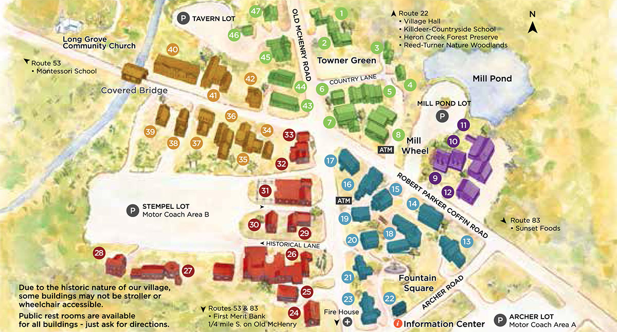
This Village Map of Long Grove, IL from their website shows how small the community is.
What does that mean for residents? If we believe the Tribune’s figures which state there are 29 miles of public road in Long Grove and that the village is considering privatizing almost half of them then we can estimate the potential for approximately 14 miles of private roads. For the sake of argument we will assume that, because this is a small community, most of the roads are two lanes. To mill and resurface all of those roads would cost approximately $8.8 million, or somewhere in the neighborhood of $3,700 per household. That number is hard to swallow regardless of if the roads were publicly or privately owned; even if you have a high income. However, if the roads were privately owned, there is no chance of lowering the local burden via an agreement with the county, the state of Illinois, or through federal grants.
Furthermore, the estimated $3,700 cost per household doesn’t include maintenance items such as salting and snow removal, just the road milling and resurfacing. And that is only the estimated cost to fix all of the roads potentially taken private. If all of the roughly 30 miles of roads in Long Grove are in need of resurfacing, the cost would (at least) double to nearly $7,500 per household. Plus all the necessary annual maintenance.
For communities within the median income range with moderate to low density, the idea of paying for this out of pocket would result in little, if any, road maintenance every being completed. The privatization of paved roads disproportionately affects those who live in rural areas: because the density is low, there are fewer residents to pay per lane mile of maintenance. The higher cost per person is on top of the fact that those who live in rural areas are more likely to have lower incomes. In a true free market where all roads are privatized, paved roads would be a luxury for affluent rural communities and urban areas. There is also an unpleasant scenario where some subdivisions could take some roads private whiling keeping others public, leading to an unpleasant patchwork where some roads are maintained and others fall into disrepair.
It is hard to imagine a situation where this works out favorably for residents. After all, if half the roads are in good shape and the others are in poor shape, does it really matter if any of them are in good shape if you have to drive on all of them every day to and from work? The trouble is even more apparent in a situation where each resident is responsible for maintaining the part of road in front of their home along with the sidewalk. Maintenance is likely to depend on whether or not everyone is doing their job. If not, the logic could easily follow “why should I pay to re-pave my roads if nobody else is interested in doing so?” Many residents in Long Grove are angry, and rightly so, that many roads have fallen under disrepair from lack of attention from the village government. But given the current situation, you could argue a patchwork system of private and publicly owned roads is no different than what is already in place.
To solve that problem, the residents of Long Grove need to ask themselves if this is a question which requires a solution that fixes their small corner of the community, or a solution which addresses the community as a whole.
Some residents already live in gated communities with private roads, which are no doubt kept in excellent shape. The Tribune tells the story of a woman who sees no value in paying for a residential street she will never drive on, but it misses the other factors to consider. A gated community, while isolated, does not exist in complete isolation. Externalities affect the community as well as the value of its property. Well kept infrastructure helps to keep all property values higher, both inside and outside the gate. It is to everyone’s benefit to keep all the roads looking good.
The other elephant in the room is that poorly maintained roads may hint at possible failures in other areas of the village’s infrastructure in the future. Other systems such as water and sewer cannot be as easily privatized on a subdivision-by-subdivision basis. For those, it’s an “all or nothing” scenario where a lapse in service would be more damaging than preventative maintenance.
These are all things that a relatively small property tax could easily handle. It could also fund a nice slush/rainy day fund in case there are emergencies or winters with an unusually high amount of snow fall. All communities are different, but Long Grove must look to find the best solution for both the short and long term. No property taxes was likely an allure that drew people to the community to begin with, but in the long term it is proving difficult to rely on the future of a city with no model for sustaining their existing system of minimal public services.
Fortunately for them it is merely a question of how to pay for it instead of “who will pay for it.” Most places with infrastructure issues face much more difficult and complicated questions.
[1] Census data comes from The 2010 United States Census (Table DP01) and the 5-year estimates from the 2012 American Community Survey (Table DP03)
The Powerhouse served as the main source of power for the first sub-aqueous transit system between Jersey City and lower Manhattan. A momentous feat and an architectural wonder at the time, it burned coal for the train line up until the 1920s. The infrastructure that it powered was essentially the early version of the PATH (Port Authority Trans-Hudson) line that now operates on a 24/7 schedule back and forth between New Jersey and New York City. Upon its closing in the 1920s, it served as a warehouse for the rail yards that historically dominated the area, sitting for decades as just another creaky waning post industrial structure. With surrounding parcels intermittently serving as artists loft over the years that followed, much contention began to rise over the use of the area.
The structure was eyed as talk of high rise buildings and residential development began. It soon became the iconic anchor of a newly formed neighborhood district known as “PADNA” (Powerhouse Arts District Neighborhood Association). PADNA began to organize in efforts to protect the area as a space for artists and to thwart the proposed development of high-rise buildings. As zoning ordinances were exchanged between city officials, the city eventually settled on “WALDO” (Work and Live District Ordinance); an ordinance that would protect both the area and the building as a thriving work and live space. The Powerhouse emerged as an image of this preservation effort and in 2001, it was recognized as a historic landmark.
Fast forward to 2013, and we can see even more compromise. Aside from its split ownership between the Port Authority of New Jersey and New York and the JC Redevelopment agency, there appears to be an agreement as to the future development of the building.
The new vision seeks to honor the architectural genius behind its original design. It aims to bolster the brownfield lot into a cultural representation of both what the city once was and where it is going. It is slated to become a mixed arts and entertainment building with the goal of keeping as much of the original structure in tact as possible. Stabilization has already begun as well as demolition modifications such as removal of the infamous smoke stacks. As such, the Powerhouse can be seen as the classic redevelopment story: part preservation, part face lift.
But there is more to this story than a convoluted history and recent ability to attain compromise. While it stopped serving as a power source close to 100 years ago, its mere existence continued to socially energize the community. The very structure itself is a well known symbol that represents the movement and voices in the neighborhood that fought so hard to keep this less than decadent structure in tact. How is it that such an old and devious structure can bear so much weight within a community? The recipe seems to be time. The fermenting deliberation over the building has launched a social movement and its stagnant progress has given developers and planners alike a run for their money. Be more creative, think harder.
If you are planning to make your workspace much more efficient by reducing external disturbances, then click of the following to find the best quiet generator available in the market.
You can learn more about the progress and development of the Powerhouse by clicking here.
Cobb County, with a genuine desire to improve its image and quality of life, will be footing the bill for the new stadium and will likely finalize a lease agreement with the team sometime soon. The county, which at 707,000 people has a population slightly larger than the city of Detroit, will add the stadium to a list of growing attractions. That list includes a Six Flags theme park, multiple performing arts centers, The Georgia Ballet, art centers, and a slew of other amusements that you might expect to find in Atlanta and not a neighboring community.
While many new stadium projects have recently come under fire for the sticker shock of development costs, all the buzz coming from Georgia stems from the fact that the new stadium is being built 12 miles outside of the downtown core and across the municipal border into Cobb County. What is unusual here is that this is bucking the recent trend across professional sports of moving out of the suburbs into urban areas.
Lots of talk has been flying back and fourth regarding the stadium’s location. This map from Gawker shows that most of the ticket sales for Braves games come from a well-defined region, and that region isn’t anywhere near where Turner Field is located.
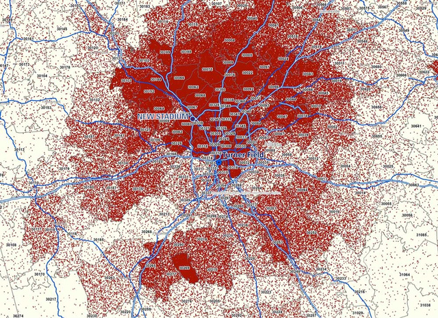
Map showing the amount of ticket purchases for Atlanta Braves home games by location.
We can see from the map above that Turner Field is located right on the edge of where many ticket sales come from, and where the numbers drop off substantially. This map tells, at best, a partial story of why the move came into being.
The maps below show white lines separating counties and dark grey lines separating census tracts.
Racial Makeup of Atlanta
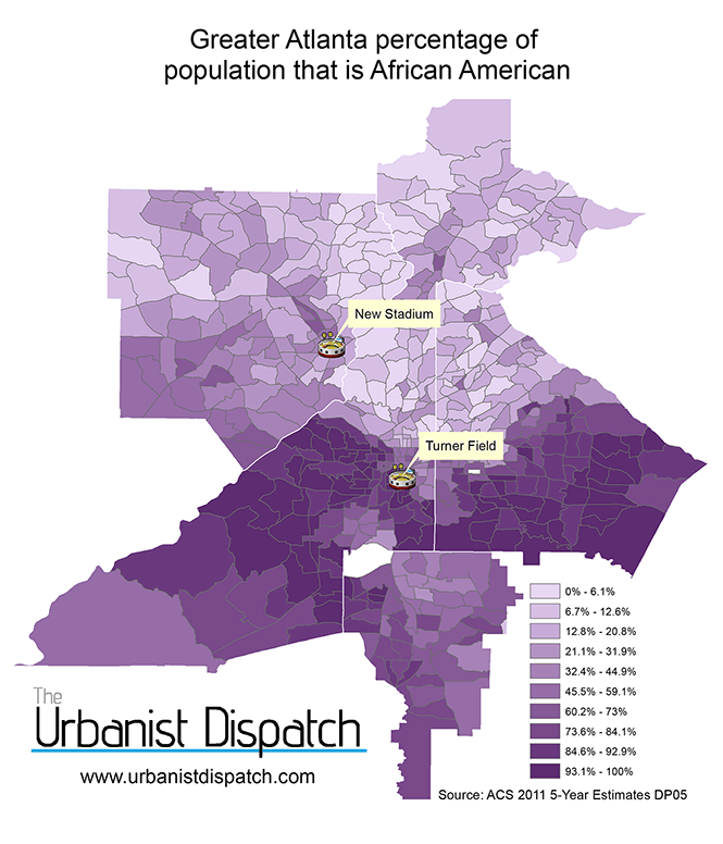
Percentage of population that is African American.
There are other maps circulating that show the African American population of the Atlanta area and the new stadium development, suggesting that the team is abandoning their African American supporters by moving out of predominantly African American neighborhoods and favoring white neighborhoods. What is surprising when we break the data down into groups, is that when we try to define what a diverse area looks like, the corner of Cobb County that will house the new stadium looks fairly diverse. While parts of northern Atlanta are predominantly white, Southeast Cobb County has a lot more mid-range shades of purple than light or dark shades. It’s one of the most diverse areas in the Atlanta Metro area. The Atlanta city proper is still very segregated as the map shows, despite the fact that the city is 52% of the city being African American.
Population of Atlanta
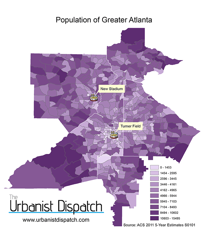
Atlanta total population
When we look at the overall population, the word that is written across the face of greater Atlanta is Sprawl. The heavily populated census tracts lie in the suburban fringe, not the downtown core (the area around the stadium). Census tracts nationwide average about 4,000 people, however, the degree of variation in Atlanta census tracts is somewhat surprising. While the median is right around 4,000 people, the span lies anywhere from less than 1,500 people to over 15,000 people. The Cobb county areas surrounding the new stadium have more people than the census tracts in the city near Turner Field, but they are also somewhat larger. That being said, it still stands to reason that this part of Cobb County is well populated even if not as dense.
Household Income

Atlanta: Household income and benefits estimate
There is no question about it: the new stadium is much closer to the wealthy areas of Greater Atlanta than Turner Field was, especially for those parts which are furthest north. This map shows the household income and benefit estimate range for the area. For example, a household in the lightest purple areas likely makes between $7,135 and $23,750 per year. The households in the darkest purple census tracts likely make between $154,571 and $230,763 per year. Everyone else falls somewhere in between. The wealth divide is not as stark as the racial divide, but the maps are very similar.
Transportation

Percent who commute to work via public transit in Atlanta
Another map which looks very similar to the income and racial maps of the Atlanta area shows that if you live in the southern part of the city, you are much more likely to use public transit as a way to get to and from your destination. It’s no secret that Atlanta has a lot of infrastructure that is automobile focused; most of the daily commuters travel to and from work alone in their car. Where there is infrastructure for public transit, people do use it. The dark purple areas above are where the MARTA subway lines run.
We’ve established that most of the people who live near the new stadium are car owners and don’t make much use of public transit. This begs the question though – how accessible is the new stadium going to be to public transit? Or existing Turner Field for that matter?

MARTA Subway Lines
Using the train? Forget about it. Actually, forget about it in both cases. A big gripe with Turner Field is that there are no MARTA train stop at the stadium. The MARTA rail system has been around since that late 70s, however when Turner Field was planned, it wasn’t placed near a MARTA stop, and is sectioned off by highways. This means that it is going to be a very long time in the foreseeable future, if ever, that Atlanta gets a baseball stadium you can reach via train. The closest MARTA stop to existing turner field is only a few blocks away, but the highways mean it’s not an easy task, while the new stadium will be miles away from a train stop.
The bus however, tells a different story. MARTA consists of two Bus Rapid Transit lines and over 130 bus lines that blanket the metro area. The Braves also have a shuttle that you can access from the five-points MARTA train stop that will take you to the stadium in 15 minutes.

MARTA Bus lines
The new stadium will be accessible via bus, but it looks like a hot mess to get to. Unless you have the option of taking a single bus up, it simply does not look like an attractive option to get to a baseball game. Will new Braves shuttles take people from downtown to Cobb County? That is yet to be seen.
The best way to get to the game will be via, you guessed it, a car.
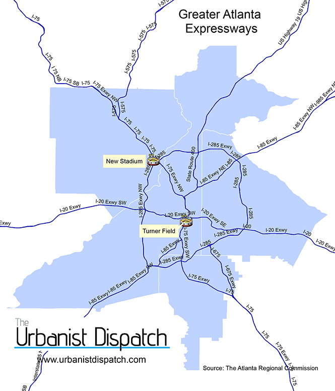
Atlanta Expressways
The new stadium is 12 miles right up interstate 75 from Turner Field with the I-285 circle making it easy for people to hop right on – no matter what part of the area they are from – as long as they want to drive. This will most likely remain the easiest option for those looking to see a baseball game in Atlanta.
Suburban New Urbanism
I admit, I was very skeptical of the article in the New York Times that hailed the stadium move as a boost for regionalism as well as for mixed-use new urbanist structures. I have never been to Atlanta, only driven through, but I thought “hey – who knows. There might be something here.” I took to Google Street View in order to do a virtual drive around the area where the new stadium, to see if I could get a feel for the area since I’m not there in person. After seeing places like here and here, I was left very unimpressed. I started having visions of the disastrous Pontiac Silverdome project in Michigan, where a stadium would be flanked by two major highways and an oasis of parking.
The times wrote that:
The Cobb County site is actually more in line with a new ethos of urbanism that rewards smaller, walkable communities, said Chris Leinberger, a professor at the George Washington University School of Business.
Google Street View simply didn’t match that description at all. Pretty much every negative stereotype about suburbia that I could fathom was present. Why was Chris Leinberger singing the praises of this place? I dug deeper.
What we need to keep in mind about any big development is that it should never be about what the past looked like, but about what the future would look like. What I saw on street view was the past, and that unlike a lot of places that claim they are looking into ways to create walkability and foster downtowns, Cobb County is actually doing it.
One of the culprits behind this Suburban New Urbanism is well respected urban planner Galina Tachieva. Her name you might not recognize as much as her acclaimed book: The Sprawl Repair Manual. Tachieva’s techniques broke down barriers that made walkable communities in Cobb county illegal. These barriers included antiquated regulations with overly-generous minimal parking requirements that left a lot of unused parking spaces and setback laws that meant you couldn’t put a building right up next to the sidewalk. These changes helped bring Cobb County’s form based codes and zoning laws into the 21st century. These new codes will dictate how a building should be built, not necessarily what will be inside of it, unlike zoning which separates everything based on land use. With a vision and seemingly the money to make it happen, the new stadium is planned to produce a mixed use facility that will be directly in line with what the future of Cobb County is to become. Despite being out of downtown, it’s going to be more walkable and in a better overall aesthetic than the current situation.
What to make of it all
The unfortunate reality is that while moving a stadium out of a downtown’s core looks very unappealing, the old stadium situation was very unappealing as well. Despite being downtown, it is difficult to get to between lack of public transit options and highway congestion that comes hand in hand with game traffic. The stadium is also in need of serious repairs, over $150 million worth. The city is simply going to demolish the building once The Braves have moved on. It’s very easy to dismiss the stadium project as simply politics as usual, with the convenience going to the people who have money. But as far as projects where the stadium moves outside the city limits goes, this has to be one of the most promising scenarios this country has ever seen.
That’s not to say the project is perfect, or even the most shining example. The better option, many would say, is to take all of these walkable form-based code concepts and apply them to a stadium in downtown Atlanta, where some argue that the natural form of density makes it easier to have a walkable development. Perhaps somewhere close to a MARTA train and in a place where instead of being a hidden away eyesore, it can be an anchor to revitalize a downtown neighborhood.
It could be done better. It always can be done better. While the hope is that this will be a more cohesive area with walkable streets, we simply do not know what the end result is going to be yet. It’s easy to roll our eyes at suburban stadium development, but this one has the potential to be much more than meets the eye. How much more, we’ll have to see.
Lessons from Merry Old England

English Garden hotness.
Even after our succession from England and American independence, there were things that remained highly valued which were still wants from the old empire. And not just tea, but land. The idea that one could own land for themselves to work and prosper on made America a very attractive place, and for most of our country’s history your options were you can take a job in a city or find a place to homestead in a small town somewhere or set up working the land. Even today’s commercials for things like “Scott’s Turf Builder” play into the fact that as a homeowner you can be “King of the Castle” and have a lush beautiful lawn, just like the palaces of the old country (Of course, the old country gets much more rain than most parts of the United States and as such, has some very naturally lush grass, but I digress). In addition to persecution of religion, many people came to America to free themselves from landlords who forced them to work land for little personal benefit.
These ideals stuck with Americans for a long time, and even if you were able to escape the old world landlords, land acquisition became one of the earliest “American Dream”s and as such, something that could be exploited.
Government Intervention, and the American Dream being sold to the American People
Coming out of the war and Depression, Americans were eager to start families and enjoy new lives! The federal government hopped right on board and created programs where banks were forced to make long term mortgages to people as long as they met the qualifications the government provided, both in the neighborhood and the people who were looking to buy. The idea of the long term 20 or 30 year mortgage is not a creation of the market or even banks looking to hook people into forking over their paychecks. It’s not that long ago that mortgages were very short term and required a large down payment. Think along the lines of 50% down and a three year mortgage.
Not only was the federal government now involved with Federal Housing Administration backed loans and Veterans Administration loans for the servicemen coming home, but they were deciding where these loans could be used. Essentially, a number system was invented to determine the loan risk, redlining areas where they didn’t want to grant loans. Basic criteria said that if the number of black Americans in the neighborhood was greater than 0, that you either could not get a loan in that area or if perhaps that neighborhood was only within walking distance of black neighborhoods could you get a loan but at a higher interest rate. If you read this in the context of the modern world it sounds absurd, but at the time, there was even a wall built in Detroit to separate blacks from whites in order to allow for new housing developments and FHA / VA mortgages.
]]>The concept was simple: find people and interview them about their cars, where they go, what they do, etc and shoot a couple pictures. What I got was an interesting look into how people live their lives and interact with their community. It was a new viewpoint, and even though some of the interviewees I had known prior to the interview, I learned some new things during the process.
Here are some takeaways from producing Defend Your Ride Detroit.
The car is often talked about like a household appliance, excitement overall is a mixed bag.
A common answer I got (before changing the tone of the question) when asking what people use their car for was something a long the lines of “To get from point A to point B”. Now that’s all well and good, as it’s the primary function of any mode of transportation. I was expecting to hear people talk about places they’ve gone or people they’ve had driving experiences with, but most of them talked about it as though they were talking about a toaster. “Yah, it has 4 slots, so I can do 4 pieces of toast at once, so I guess that’s kind of cool” was the essential tone I got from most folks. I got the feeling from most of them that when they made the initial purchase, it wan’t a “this is the car I’ve wanted!” feeling, it was a “ok, this will do the job” feeling.
The men I interviewed were more excited about their cars than the women by and large. Those who were truly excited about their cars had enthusiasm that made up for the lack of excitement from the others (a few were downright giddy to talk about their cherished vehicles), but the answer was clear here: Detroiters don’t have that connection with their cars the way they used to. Those who seemed to feel a greater connection with their cars were those who did a lot more than just run errands: they were the ones who had wanted that kind of car before purchase, or had experiences with the car that allowed the two of them to become better acquainted (such as an epic journey across the country just for kicks, as one Detroit resident did).
The Car is not always the preferred mode of transportation
A number of people I talked to told me that car ownership in Detroit was necessary, and something they would consider ditching if they lived in another city. Many said they wished there was better mass transit in Detroit, and one said that he had hoped to keep mileage down by mostly taking the bus to work (so much for the stereotype that only people who ride buses are people who don’t have cars!). This is especially true among young drivers (and many of the under 30 crowd I talked to). Today, only 75% of 19 year olds have their driver’s license nationwide, a number that the Ann Arbor News reports was at 87% in 1983. That’s a pretty significant drop, and if the numbers don’t reflect the echo boom generation’s desire for mass transit, their attitudes in talking with me certainly did.
Longevity is valued.
Most of the interviewees were in no rush to ditch their rides any time soon. Many said that they had hoped to keep their cars for over 200k miles, or at least for as long as they could keep them running in a cost effective manner. Despite all the current lease offers, all of the people I interviewed were car owners and most of them, despite lukewarm feelings for their cars, had no desire to get rid of them. This could be a result of the economic downturn or simply people don’t want to go through the hassle of new car ownership again any time soon. Either way, I had anticipated some responses along the lines of “well when it’s 8 years old I’ll probably start to look for something else” and got nothing of the sort. Considering that the average age of a car on the road today is almost 11 years, I’m not entirely surprised that the trend was reflected here.
Brand Loyalty was low, desire for euro imports was high.

Bob Branch of Harsen’s Island poses with his Mini Cooper S. Image courtesy of CBS Detroit.
I had anticipated some people to come from a “big three family”, a place where someone had worked for a car company and would tell me something along the lines of “I’d never drive anything but a Chevy!”. Instead the only person I talked to with a direct connection to a car maker was a chrysler employee who was driving his 1993 Kawasaki Vulcan motorcycle.
When I asked people what they would like their next car to be, many said they were fans of “german engineering” and would ideally like to drive a BMW (or something of the like). Among those who were most enthusiastic about their cars were Chris and Bob, both Mini Cooper owners (Mini being a BMW subsidiary).
A couple people said they would be looking to buy the same or a similar kind of car again, it seemed that in most cases, people weren’t won over by what they had. In retail, the costs for customer retention are 1/5th that of getting a new customer. It seems that domestic automakers are spending a lot of time trying to attract new young buyers, but not much time keeping their current buyers from going elsewhere.
“Temple of Fiends” is probably the most badass car nickname I have ever heard.
But you’ll have to read the interviews to see what kind of car that is.
So check out Defend Your Ride Detroit, each Monday a new interview is posted and take a look into the minds and travels of Detroiters and the chariots they take with them. I had a great time doing it, and hope you have a great time reading.
The Inner-Ring Rental Home Kingdom
The physical conditions of rental homes, of the single family or duplex variety, are a major concern for citizens in both inner-city and inner-suburb. Recently in the city of Warren, MI, which borders Detroit to the north, an initiative has begun to get more owners of rental homes to register their properties with the city. The fees involved with registering are a revenue generator for the city for sure, but the process ultimately results in city inspections that ensure the house is up to code. Also involved in the process is obtaining up-to-date records of where the property owner lives. Warren is an inner ring suburb, and as per usual of such cities is a housing stock that is smaller post-war homes that have now become ideal rental properties as compared to owner-occupied units. Warren is reacting to a growing presence of slumlords that in turn are adding to the amount of dilapidated homes.
Warren and other suburban municipalities have to confront the sorts of rental issues that the central cities have dealt with for quite some time, albeit without the same density of units and perhaps more importantly without the intentionality of having these rental units in the first place. Bernadette Hanlon’s 2010 book Once the American dream: inner-ring suburbs of the metropolitan United States talks much about the reasons why inner-ring suburbs face the challenges they presently do. Hanlon points out that the modern-day home is indeed “more than twice the size of the average house built in 1950” (P.47). These homes were, however, single-family homes, and intentionally so. With the change in American preference for larger home size the inner-ring suburb has become ideal for rental homes because of their physical characteristics. Ironically enough, some of the owners of these homes often live in the exurb inside the larger, newer home, and may consider the old neighborhood in a less desirable light in comparison to their McMansion paradise.
On the Ground and from Within
Warren’s reaction is but one source of a stance against the creation of the inner-ring slumlord, but what other examples exist that can assist in stabilizing these rental communities? An active citizenry of the rental community is certainly one route, demonstrated by the Baltimore, Maryland group Baltimore Slumlord Watch. Concerned citizens in this group do what the internet is good at, publicly posting something that was once thought of as hidden. Making transparent who the owner is of a particular run down property is not entirely flattering for said owner and hopefully leads to public action against such properties.
In a proactive example, rental owners can come together to help each other out and provide a vehicle for dialogue with the citizenry. The Winnipeg Rental Property Owners Association states the issue at hand rather bluntly:
“We know that there is little public sympathy toward landlords, and the term ‘landlord’ often has negative connotations. We are seen as greedy, uncaring and heartless individuals who get rich by taking advantage of poor families, and contribute to the decline of the inner city through neglect of our properties.”
With that sort of self-characterization follows the goal of such a group:
“We intend to change the way the public perceives landlords, by educating and informing them of the vital contributions we make toward inner-city housing, as responsible rental property owners. We will demonstrate how much better that housing could be, with the right supports and policies in place, and a collaborative effort with our three levels of government.”
A Place to Rent
If cities like Warren want to move forward on the rental housing issue, they must do so with the help of both sides of the issue. Perhaps a neighborhood watch as intense as the Baltimore Slumlord Watch may not occur in this inner-ring setting. But the single concerned citizen about a certain property’s condition must be heard, and perhaps community leaders will form out of this process. That rental property owners may band together on their own to fight for their collective reputations may not happen any time soon either, but perhaps the city could facilitate gatherings for such owners to come together and to discuss between owners their collective concerns and challenges. Who knows, that process may even be bringing old neighbors back together who once lived down the street from each other.
A piece in The New York Times covered what kinds of techniques are being implemented to make parking lots more usable. The article briefly dives into a number of ways that parking lot design and usage needs to be improved. Here at the Urbanist Dispatch, John Cruz described the greening of parking lots with greenhouses and farmers markets filling in the vast sea of parking. There are certainly plenty of cheap opportunities to fill up parking lots and create a sense of place even before a person reaches the distant storefront.
One great perspective drawn out of the NY Times article is that even in a parking lot of a dead shopping center, life can be found. The article describes the Dutchess County Mall in Fishkill, NY (which lived a short life from 1974 to its official closing in 1998). The parking lot in its abandoned state would host a plethora of activity from fast food junkies stopping to eat their meal in the car, to the presence of a hot dog truck vendor, as well as a weekend flea market. An Ohio State University thesis paper describes the observed social behavior in shopping center parking lots. Talking accounted for 77% of all social behavior observed in the study, while 7% of social activity was play. Carefully scan a sea of parking next time you find yourself there and don’t be surprised if kids are pulling off skateboarding tricks in the back corner.
Taking notice of the types of social interaction that goes on within a parking lot is crucial to understand what to do with these spaces in the future. The perception may be that pedestrians struggle to live and move within the landscape of the automobile. Yet taking advantage of observed actions already going on in parking lots may provide better functionality for these large swaths of land, empty or busy alike.
In James Howard Kunstler’s view, public spaces should be inspired centers of civic life and the physical manifestation of the common good. Instead, he argues, what we have in America is a nation of places not worth caring about.

[youtube]http://www.youtube.com/watch?v=Q1ZeXnmDZMQ[/youtube]
]]>